
Cumberland Plateau Tailwaters Field Report: Caney Fork, Center Hill, and Middle Tennessee's Cold-Water Trout
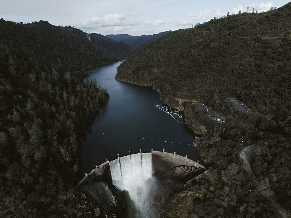
Most of Tennessee is too warm for trout. The rivers that drain the Cumberland Plateau and the basins around Nashville run through limestone and sandstone country that heats up by early summer, and left alone, they would hold smallmouth bass, catfish, and rough fish rather than anything resembling a cold-water fishery. The Caney Fork is the exception, and it is an exception built entirely by engineering rather than climate. Below Center Hill Dam, the water coming out of the reservoir is not the sun-warmed surface water of Center Hill Lake. It is pulled from deep in the reservoir's water column, where it stays cold year-round, and when the US Army Corps of Engineers releases it downstream, it arrives in the Caney Fork at a temperature more typical of a Rocky Mountain freestone stream than a Middle Tennessee river in August.
The result is a trout fishery roughly 30 miles long, stocked and managed by the Tennessee Wildlife Resources Agency, sitting less than an hour from downtown Nashville and threaded through towns -- Smithville, Sparta, Carthage -- that most visitors know, if at all, as pass-through points on the way to somewhere else. This is a field report on that fishery and the plateau country around it: the dam-driven hydrology that makes the cold water possible, the trout and hatch cycles that depend on it, the native smallmouth and warm-water fish that occupy the rest of the basin once the tailwater effect fades, and the small, fragmented guide economy that has grown up around a fishery most anglers outside Tennessee have never heard of. It is also, unavoidably, a report about a fishery governed by a hydropower schedule -- one where water levels can rise several feet in the time it takes to eat lunch, and where planning a trip means checking a generation schedule as carefully as a weather forecast.
Ecology Snapshot
Center Hill Dam sits on the Caney Fork River in DeKalb County, impounding Center Hill Lake, a reservoir built and operated by the US Army Corps of Engineers Nashville District primarily for flood control, hydropower, and navigation support on the Cumberland River system. Like most large Corps reservoirs built for power generation, Center Hill Lake stratifies thermally in the warmer months: warm water sits near the surface, and cold, oxygen-poor to moderately-oxygenated water settles into the lower depths. Center Hill Dam's intakes draw from that lower layer, so the water released downstream runs cold even in mid-summer -- commonly cited in the roughly 50 to 55 degree F range -- regardless of how hot the air temperature gets on the plateau above.
That cold, stable output is what makes the Caney Fork a trout stream rather than a smallmouth and rough-fish river like most of its neighbors. TWRA stocks the tailwater with rainbow trout and brown trout, and the Caney Fork is one of the relatively small number of Tennessee tailwaters where brown trout show meaningful natural reproduction, supplementing the hatchery program rather than depending on it entirely. The cold-water reach extends roughly 30 miles downstream of the dam before warming, tributary inflow, and distance from the cold-water source erode the trout habitat and the river transitions back toward a warm-water fishery as it nears its confluence with the Cumberland River at Carthage.
The trout program sits inside a broader native fish community that has nothing to do with the dam. Upstream of Center Hill Lake and across the wider Cumberland Plateau, the same basin holds native smallmouth bass in cooler, higher-gradient stream reaches, along with warm-water species like muskellunge and walleye in the larger river sections and reservoir arms where habitat suits them. The trout fishery is an engineered overlay on top of a plateau ecosystem that, left to its own devices, is a warm-water and native black bass system -- which is part of what makes the tailwater interesting: two fundamentally different fish communities, cold-water and warm-water, occupying the same river system a few miles apart, separated by nothing but a dam's intake depth.
The Cumberland Plateau itself, rising to roughly 1,800 to 2,300 feet in elevation west of Nashville, gives this whole system its underlying geology and drainage pattern. Public land units scattered across the plateau -- the Catoosa Wildlife Management Area under TWRA management, the Obed Wild and Scenic River under National Park Service administration, and the Big South Fork National River and Recreation Area jointly managed by the Park Service and US Forest Service -- protect large blocks of the plateau's native stream habitat, even though most of these units sit outside the Caney Fork's specific cold-water reach. Together, the managed trout tailwater and the surrounding public plateau land form a single regional fishery story: one engineered cold-water stretch embedded in a much larger native warm-water and coolwater system.
What the Interface Creates
The line between the cold tailwater and the warm river downstream is not a wall, it is a gradient, and that gradient is where a lot of the Caney Fork's biological productivity concentrates. Immediately below the dam, consistently cold, well-oxygenated water supports classic tailwater trout-stream insect life -- midges, caddis, mayflies, and sculpin populations -- that in turn support both stocked and naturally-reproduced trout at a density Tennessee's warm-water rivers simply cannot match. Researchers with the US Geological Survey and academic partners have studied Caney Fork tailwater hydrology and thermal dynamics specifically because it is a clean example of how a dam's operating pattern reshapes a river's biology, not just its flow.
Moving downstream, the interface shifts. As tributary inflow warms the water and the cold-water influence from the dam fades with distance, the trout habitat gives way to a transition zone and then to warm-water habitat more typical of the Cumberland Plateau's other rivers -- smallmouth bass water, then eventually the mixed warm-water fishery of the lower Caney Fork and the Cumberland River itself. That transition zone is itself a distinct fishery: some anglers specifically target the water where trout and smallmouth overlap, particularly in cooler months when the thermal gradient compresses and both species tolerate the middle ground.
The generation schedule is the other half of what the interface creates. Center Hill Dam is a peaking hydropower facility, which means the Corps releases water in pulses tied to regional power demand rather than as a constant flow. When generators run, flow and water level in the tailwater rise fast -- often within minutes -- and when they stop, the river drops back down over a similar timeframe. That pulsing regime does more than create a safety hazard for waders; it also drives nutrient and insect drift downstream in a way that shapes where and when trout feed, making the generation schedule as much a biological variable as a boating-safety one.
Migration and Timing Signals
Trout in a tailwater fishery do not migrate the way anadromous or highly mobile river fish do, but the Caney Fork's productivity is still highly seasonal, and reading that seasonality is central to fishing it well. Insect hatches follow a fairly conventional cool-climate tailwater calendar: spring brings the most reliable hatch activity and the most consistent dry-fly opportunities, as rising water temperatures (within the cold-water band the dam maintains) and lengthening days trigger emergence cycles for the tailwater's midge, caddis, and mayfly populations. Fall brings a second strong window, often considered by regular Caney Fork anglers to rival or exceed spring for both hatch activity and fish behavior, as cooling air temperatures and stable dam-release water temperatures combine with less fishing pressure than the height of summer.
Summer fishing is viable but more dependent on timing around generation -- cold releases keep the immediate tailwater fishable even in July and August heat, but flows tend to be more aggressively managed for power demand, and anglers who do not plan around the release schedule can find themselves either fishing a trickle or wading into a rapidly rising river. Winter fishing holds up reasonably well on the Caney Fork relative to freestone trout streams elsewhere in the region, precisely because the dam keeps water temperatures in a narrower band than an unregulated stream would see, buffering the fishery against the hardest winter cold snaps.
Because the generation schedule -- not the calendar -- is the dominant variable in whether a given day fishes well, planning around it is the single most important timing skill on this river. The Corps publishes generation information, and checking it before a trip (and again the morning of) is treated by regular Caney Fork anglers the way saltwater anglers treat tide charts: not optional, and directly determinative of where and how the day's fishing will go.
On the Ground
Smithville, in DeKalb County near the dam and the upper end of Center Hill Lake, functions as the closest true basecamp to the tailwater itself, with lake and river access, marina and resort infrastructure tied to Center Hill Lake's broader recreational economy, and reasonable proximity to both the trout water below the dam and the lake fishery above it. Sparta, to the east on the plateau, sits closer to the upper Caney Fork drainage and the Falling Water tailwater, and serves as a gateway both to the trout program and to plateau public lands further out -- a smaller, quieter alternative to Smithville with its own lodging and outfitting presence.
Carthage, at the Caney Fork's confluence with the Cumberland River, marks roughly the downstream end of the trout fishery and the point where the character of the water shifts toward the mixed warm-water fishing of the Cumberland corridor. It is also a practical staging point for anglers working the transition zone or continuing on to the Cumberland River itself, which runs through Hartsville and on toward Nashville. Lebanon, further west along the I-40 corridor, functions less as a fishing-specific basecamp and more as a broader lodging and services hub for visitors splitting time between the Cumberland Plateau tailwaters and the Nashville metro area -- a reasonable compromise for travelers who want plateau access without fully leaving city infrastructure behind.
Further out on the plateau, the Catoosa Wildlife Management Area, the Obed Wild and Scenic River, and the Big South Fork National River and Recreation Area extend the regional trip beyond the tailwater itself, offering paddling, hiking, and native-species fishing on public land for visitors who want to pair a day on the Caney Fork with a day on unregulated plateau water. None of these units are trout fisheries in the way the Caney Fork tailwater is, but they round out a multi-day itinerary and give the region a public-land backbone that a single dam-driven fishery, on its own, would not have. Across all of these towns and public land units, the pattern holds: this is a fishery worked out of small, local, often family-run lodging and marina operations rather than any large resort-branded infrastructure, which shapes both how visitors find operators and how those operators run their businesses.
Planning Your Trip: A Vertical-by-Vertical Breakdown
Tailwater Trout. Target: stocked rainbow trout and stocked-plus-naturally-reproduced brown trout in the Caney Fork below Center Hill Dam. Peak: spring and fall for the most consistent hatch activity and dry-fly opportunity, with viable fishing year-round due to the dam's stabilizing effect on water temperature. Where: the roughly 30-mile cold-water reach immediately below the dam, with the most consistent trout density and access nearest the dam itself. Key dependency: the Center Hill Dam generation schedule -- flows and water levels can change rapidly when the Corps runs generators, and checking the release schedule before and during a trip is essential for both fish behavior and wading safety.
Native Smallmouth Bass. Target: native smallmouth bass in cooler, higher-gradient plateau streams and river reaches outside the direct trout influence, including waters associated with the Obed Wild and Scenic River, Big South Fork National River and Recreation Area, and the upper Caney Fork drainage above Center Hill Lake. Peak: late spring through early fall, with spring pre-spawn and fall feeding periods typically producing the most consistent action. Where: free-flowing, higher-gradient plateau streams rather than the dam-cooled tailwater itself. Key dependency: seasonal flow and water clarity, which on unregulated plateau streams depend on rainfall rather than a dam release schedule.
Warm-Water Transition Zone. Target: trout-to-smallmouth transition water in the lower Caney Fork as it approaches its confluence with the Cumberland River near Carthage. Peak: cooler months (late fall through early spring) when the thermal gradient between the cold tailwater and the warming downstream reach compresses, allowing more overlap between species. Where: the downstream half of the tailwater and the reach approaching Carthage. Key dependency: distance-driven warming and tributary inflow, both of which shift the effective trout/warm-water boundary depending on season and recent weather.
Cumberland River Main Stem. Target: warm-water species including bass, catfish, and other river fish along the Cumberland River corridor through Hartsville, Carthage, and toward Nashville. Peak: broadly a warm-season fishery, spring through fall, following conventional Middle Tennessee warm-water patterns rather than the dam-cooled trout calendar. Where: the Cumberland main stem downstream of the Caney Fork confluence. Key dependency: general river flow and navigation traffic rather than a specific hydropower release schedule, though upstream reservoir operations on the broader Cumberland system still influence flow.
Key Takeaways
The Caney Fork tailwater exists because Center Hill Dam draws cold water from deep in Center Hill Lake and releases it downstream, holding the river in a roughly 50 to 55 degree F range regardless of season -- a dam-engineered cold-water fishery inside a naturally warm-water river system, sustaining trout for roughly 30 miles below the dam before the effect fades.
Fishing this system well means fishing the generation schedule as much as the calendar. Center Hill Dam is a peaking hydropower facility, and water levels in the tailwater can rise or fall substantially within a short window whenever the Corps runs or stops generators, which affects both trout behavior and basic wading safety.
The Cumberland Plateau holds two distinct fisheries stacked on top of each other in the same basin: a dam-created cold-water trout fishery in the immediate tailwater, and a native warm-water fishery -- smallmouth bass, muskellunge, walleye -- in the free-flowing plateau streams and the Cumberland River corridor beyond the tailwater's reach. Understanding which fishery a given stretch of water belongs to, and why, is the difference between fishing the Caney Fork on its own terms and treating it as generic river access.
For the Operators
The guide and lodging economy around the Caney Fork and Center Hill tailwater is small by design and by geography. This is not a fishery with dozens of competing outfitters; it is realistically a handful to perhaps a dozen or more established commercial guides working the trout water, alongside a modest number of lake resort and marina operations around Center Hill Lake itself. Most of this business is still found the old way -- word of mouth, local reputation, repeat clients -- rather than through the review-aggregator and marketplace discovery channels that dominate booking behavior in larger fisheries. That fragmentation is both the risk and the opportunity: a handful of long-tenured operations built a real, durable local reputation over decades, but several of the most established Caney Fork guide and lodge operations are multi-decade, often family-run businesses now facing a real succession question -- who inherits the client relationships, the local knowledge of the generation schedule and hatch timing, and the reputation, when a founding guide or lodge owner steps back.
The bigger opportunity is less about individual operators and more about how this fishery gets talked about. The Caney Fork's actual story -- a dam pulling cold water from a reservoir's depths to sustain a trout fishery an hour from Nashville, governed by a hydropower schedule and a real insect-hatch calendar -- is a more specific and more credible hook than the generic 'trout guide near Nashville' framing most of this fishery's online presence currently uses. Elevating that story, told accurately and without overclaiming specific numbers or records, is a genuine differentiation opportunity in a market where almost no one is currently telling it well. Content built around generation-schedule planning, hatch timing, and the honest distinction between the tailwater trout fishery and the plateau's native warm-water fishing gives visiting anglers something to plan a trip around beyond a generic booking page, and it gives established operators a way to signal expertise that a directory listing cannot.
None of this is a comment on any specific operator's business or practices; it is an observation about a market structure -- small, fragmented, locally-discovered, and currently underserved on the content side relative to how interesting the underlying fishery actually is. A fishery this specific, with a real dam-driven ecological mechanism behind it, rewards operators and destination marketers willing to explain that mechanism honestly rather than defaulting to generic outdoor-recreation copy that could describe almost any trout stream in the country.
Citations and Sources
This report draws on well-established public information from federal and state resource agencies and conservation organizations active on the Caney Fork and Cumberland Plateau; readers planning a trip should confirm current conditions, regulations, and generation schedules directly with these agencies before heading out.
Agencies and sources
Key sources and agencies referenced include the Tennessee Wildlife Resources Agency (TWRA), which manages trout stocking and fishing regulations on the Caney Fork tailwater; the US Army Corps of Engineers Nashville District, which operates Center Hill Dam and publishes generation and lake-level information; the US Geological Survey, which has conducted hydrology and water-temperature research relevant to Caney Fork tailwater dynamics; Trout Unlimited's Tennessee council, which is active in cold-water conservation advocacy on Tennessee tailwaters including the Caney Fork; The Nature Conservancy's Tennessee chapter, which works on river and watershed conservation across the state; and the US Forest Service, which administers national forest lands in the broader Middle and East Tennessee region, including areas near the Cumberland Plateau's public lands. The Obed Wild and Scenic River and Big South Fork National River and Recreation Area are administered by the National Park Service, in the case of Big South Fork jointly with the US Forest Service.
Confidence note: the core hydrology claim -- that Center Hill Dam releases cold, bottom-drawn water that sustains trout habitat for roughly 30 miles downstream -- is well-established and consistent with how TWRA and USACE both describe the fishery, though exact mileage and temperature figures can vary somewhat by source and season and should be confirmed against current TWRA and USACE materials before publishing specific numbers in promotional contexts. The characterization of brown trout showing some natural reproduction on the Caney Fork reflects general public knowledge about this tailwater but is stated cautiously rather than with specific reproduction-rate figures, which are not well-established public data. The 'Falling Water tailwater' near Sparta is referenced as a named geographic feature per the brief but is treated here without specific technical claims about its scale or management, since detailed public data on it is thin. The characterization of Catoosa Wildlife Management Area is kept general and does not assert specific trout stocking there, since that claim is not well-established. The connection drawn between Cherokee and Daniel Boone National Forests and the Cumberland Plateau tailwater region is framed loosely and regionally rather than as a direct management claim, since neither forest directly administers the Caney Fork or Center Hill Dam corridor. No specific operator names, prices, client counts, or record fish figures are used anywhere in this piece, consistent with house policy against inventing figures not confirmed as well-established public knowledge.
Explore More
For related reading on other engineered and impounded Tennessee and Southeastern fisheries, see the following field reports.


Comments