
Virginia Eastern Shore Field Report: Atlantic Flyway Waterfowl, Barrier-Island Marsh, and the Seaside-Bayside Divide

Stand on the causeway into Chincoteague on a gray October afternoon and the Eastern Shore makes its argument in one look. To the east, past the town and the channel, the red-and-white Assateague Lighthouse rises out of the pines, and beyond it the Atlantic works against a barrier island that is never quite the same shape two winters running. Behind you, west across Accomack County farm country, the land runs out again into a different water entirely: the brown, sheltered marshes and guts of the Chesapeake Bay, where black ducks tip up in the creeks and the tide moves slow.
That is the whole idea of this place. Virginia's Eastern Shore, the two counties of Accomack and Northampton at the bottom of the Delmarva Peninsula, is one narrow strip of land with two coasts that behave like different countries. The seaside is ocean-facing and restless: barrier islands, inlets, shallow lagoons, eelgrass meadows and salt marsh that the Atlantic rebuilds every storm season. The bayside faces the Chesapeake across tidal creeks, marsh peninsulas and flats that take their weather and their salinity from the Bay. The fish, the ducks, the regulations and even the size of a legal rockfish change depending on which side of Route 13 you launch.
We are writing this in the third week of October 2026. The first, short split of Virginia's duck season came and went October 9-12. Youth and veterans waterfowl day is this Saturday, October 24. The main duck season opens November 18, brant open December 19, and the Bay's fall striped bass season has been open since October 4. Fall songbird and raptor migration is under way at the southern tip.
Our earlier statewide piece, The Virginia Outdoor Field Report, set the Shore beside the Chesapeake tributaries and the Blue Ridge. This one stays on the peninsula and goes deeper.
An Ecology Snapshot: Barrier Islands, Seaside Lagoons and Bayside Marsh
The seaside: an undeveloped barrier coast
The defining fact of the seaside is what is not there. The Nature Conservancy's Volgenau Virginia Coast Reserve protects 14 undeveloped barrier and marsh islands, which TNC describes as "the longest expanse of coastal wilderness remaining on the east coast." TNC owns about 40,000 acres of barrier islands, marshes and uplands on the Shore, and with partners more than 115,000 acres are protected. The Conservancy's page puts the barrier beaches it protects and manages with partners at about 50 miles.
It is worth being precise about what that reserve is and is not. The 14 islands are TNC's reserve. Assateague's Virginia end is a federal refuge, Chincoteague National Wildlife Refuge. Fisherman Island at the peninsula's tip is its own closed refuge. Wallops Island is a separate federal property and refuge. They all belong to the same seaside system and the same chain of inlets and lagoons, but they are managed by different hands under different rules, and anyone writing or guiding here should keep them straight.
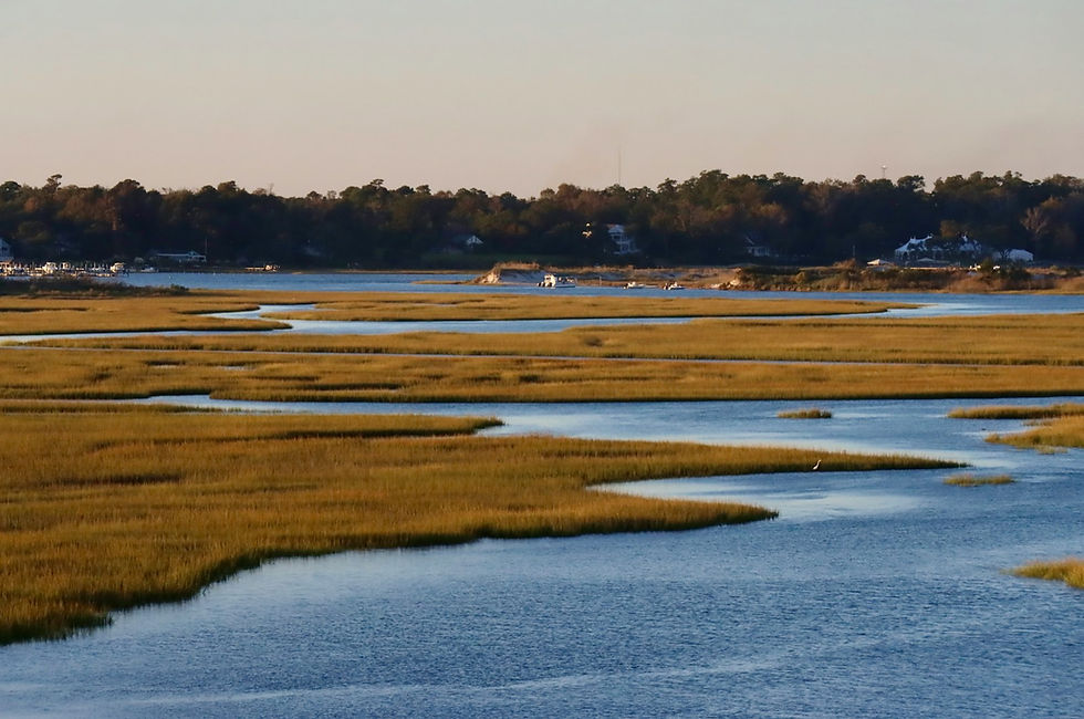
Behind the islands lies a shallow lagoon system of open bays, mudflats, salt marsh and channels that drain through a series of inlets to the ocean. Smooth cordgrass marsh fringes the lagoons and the back sides of the islands. The bottom of the open bays is the stage for the reserve's best-known recovery story: TNC and the Virginia Institute of Marine Science have worked together on what TNC calls "the largest and most successful seagrass restoration project" in the world, with more than 9,500 acres of eelgrass restored so far. TNC also reports more than 50 acres of restored oyster reef, with over 100 acres managed and monitored, and a 2017 release of 12.3 million bay scallop larvae into the eelgrass of South Bay, aimed at an eventually self-sustaining population.
The islands themselves move. They roll landward, split, rejoin and grow. Fisherman Island is the clearest example on the Shore: the U.S. Fish and Wildlife Service says it was a small site of about 25 acres in the late 1800s and that barrier-island dynamics have grown it to nearly 2,000 acres.
Science has followed the islands for decades. TNC notes that the Virginia Coast Reserve Long-Term Ecological Research program began here in 1987, making the seaside one of the most closely watched barrier coasts in the country.
The bayside: Chesapeake marsh and tidal creeks
Cross to the bayside and the system shifts from ocean-driven to Bay-driven. The water is brackish rather than full-strength salt, the wave energy is lower, and the shoreline is a long series of tidal creeks, marsh necks and shallow flats facing Pocomoke and Tangier sounds and the open Bay. Tangier Island, out in the Bay and part of Accomack County, is the most famous reminder that the Shore's bay side has its own water culture.
Saxis Wildlife Management Area is the clearest public window into the bayside marsh. Virginia DWR describes it as about 5,678 acres divided into three peninsula tracts in Accomack County, mostly tidal marsh bordered by brackish water, with forested hummocks on higher ground inland. DWR calls Saxis a breeding and wintering area for black ducks and a wintering area for Canada geese, with mallard, wigeon, pintail and teal in the marsh and diving and sea ducks, along with canvasback, redhead, scaup, goldeneye, bufflehead and mergansers, on the adjacent open water. Deer, rabbits, muskrat, foxes, raccoon, mink and river otter round out the list.
The tip of the peninsula: a migration funnel
At the southern end, where Northampton County narrows to its point between the Atlantic and the Bay, the Eastern Shore of Virginia National Wildlife Refuge occupies the last of the land. The Fish and Wildlife Service established it in 1984 as a resting and refueling stop for migrating birds and insects. Every autumn, in the refuge's words, "millions of songbirds and monarch butterflies and thousands of raptors" converge there on their way south. Birds that drift down the peninsula hit open water at the tip and stack up in the thickets and fields before crossing the Bay mouth, which is why the bottom of the Shore is one of the East Coast's notable fall migration spots.
Fisherman Island, just offshore of the tip and crossed by the Chesapeake Bay Bridge-Tunnel, is described by the Service as one of the country's most valuable stopovers for migratory birds. It supports nesting brown pelicans, royal terns and American oystercatchers, and female diamondback terrapins come ashore there to lay eggs.
What the Seaside-Bayside Divide Creates
Two duck worlds on one peninsula
The divide shows up most clearly in the birds. On the seaside, the open lagoons, eelgrass beds and inlets suit brant, the small sea goose of the Atlantic coast, along with sea ducks working the ocean and the inlet mouths. Brant are tightly tied to coastal water and to the submerged plants that grow in it, which is why restored eelgrass in the seaside bays matters to a waterfowler as much as to a fisheries scientist. On the bayside, the tidal marsh and creeks hold black ducks and other dabblers, with divers rafted on the open Bay.
None of this is a hard line. Ducks move across the peninsula with weather and tide, but a hunter who knows which shore suits which bird starts every trip ahead.
The brant picture is worth watching closely. Virginia DWR's 2025 fact sheet reports that the 2024 Atlantic brant midwinter survey estimate was 112,842 birds, below the 2023 estimate of 121,475 and 20 percent below the 2001-2024 average of 140,897. Productivity rebounded to 19.9 percent young, above the long-term average of 17 percent. The Atlantic Flyway sets brant regulations from an integrated population model adopted in 2021, and that model's prediction of 111,000 birds called for a 30-day, 1-bird season, down from the 50-day, 2-bird seasons of earlier years. Those are flyway-wide numbers, not a count of brant on the Eastern Shore, but they explain why the 2026-27 brant season on the Shore is short and tight.
Black ducks deserve the same care. DWR's fact sheet lists the 2024 statewide estimate of breeding black duck pairs at 64, down from 629 the year before. That is a Virginia breeding-pair estimate, not a measure of wintering birds, which arrive from farther north. It is still a reminder of why black ducks carry a 2-bird limit and an early-October closure in Virginia.
Species duality in the fishery
The same divide runs through the fishing. Virginia's striped bass regulation, 4VAC20-252, splits the peninsula's waters into two legal areas. The "coastal area" includes the Territorial Sea and the creeks, bays, inlets and tributaries on the seaside of Accomack and Northampton counties, including waters east of the Fisherman Island causeway. "Chesapeake Bay and its tributaries" covers Virginia's tidal Bay waters west of the Territorial Sea, minus the coastal area and the Potomac tributaries. A seaside rockfish and a bayside rockfish are legally different fish, with slots laid out in the planning section below.
Beyond rockfish, the seaside lagoons and inlets are classic summer flounder water, and the Shore's flounder tradition runs from rod and reel to the gig. Red drum and black drum roam both shores and the Bay mouth. Cobia work the Bay and the nearshore ocean in summer. Speckled trout and tautog fill in the cool months. The species list overlaps, but the habitat, the tide behavior and the fishing style change from side to side.
An undeveloped coast that stays wild
The third thing the divide creates is wildness. Because the seaside is guarded by a chain of protected islands, much of the Shore's Atlantic coast has no hotels, no boardwalk and no beach road. TNC reports that the islands support thousands of nesting shorebirds and colonial waterbirds, including piping plovers, American oystercatchers, willets and whimbrels. In winter, roughly 50 to 80 harbor and gray seals routinely haul out on Conservancy property, according to TNC, with a 2019-2020 survey counting 39 individuals in a single season.
Migration and Timing Signals for 2026-27
All seasons below are from Virginia DWR's 2026-27 migratory game bird regulations and the Virginia Marine Resources Commission's current recreational rules, as published in October 2026. Confirm current regulations with Virginia DWR and VMRC before every trip.
October: the tip lights up, rockfish open on the Bay
October is migration month at the southern tip. Songbirds, raptors and monarchs move down the peninsula and pile up at the Eastern Shore of Virginia refuge before crossing the Bay mouth. The first duck split, October 9-12, has already run, with black ducks closed for those four days. Youth and veterans waterfowl day is October 24, 2026.
On the water, the Bay's fall striped bass season opened October 4 and runs through December 31, with a 19-to-24-inch slot and 1 fish. The seaside coastal season has been open since May 16 under its 28-to-31-inch slot. Speckled trout and red drum are prime fall targets in both bays as water temperatures fall.
November: the main ducks arrive
The second duck split runs November 18-29. The Atlantic Population Canada goose season, which covers the Shore, opens November 24 and runs through November 29, then reopens December 24. Light geese open November 25 and run through March 10, 2027, at 25 per day. DWR notes that the Light Goose Conservation Order will not be offered in 2026-27. Tundra swan season, by permit only, runs November 15 through January 31 east of I-95. The application deadline for the 475 Virginia permits was September 25, 2026, so this year's draw is closed.
December and January: brant, sea ducks and the long split
The final duck split opens December 19, 2026 and runs through January 31, 2027. Atlantic brant open the same day and run December 19-31, then close and reopen January 15-31, at 1 per day and 3 in possession. Canada geese reopen December 24 and run through January 31 at 2 per day.
Sea ducks are part of this window, but there is no separate sea duck season anymore. DWR's 2026-27 regulations say the Special Sea Duck Season no longer exists. Sea ducks are hunted during the regular duck season within the overall bag. The former zone has been renamed the Special Sea Duck Area, its 800-yard buffer has been removed, and it now defines where hunters may pursue crippled waterfowl under power: the ocean waters of Virginia, the tidal waters of Northampton and Accomack counties up to the first highway bridge, and the Chesapeake Bay and its tributaries up to the first highway bridge. Back Bay and its tributaries are excluded.
Late December into January is usually the Shore's heart of winter waterfowl, depending on how hard the north freezes. Scaup limits rise from 1 to 2 per day starting January 12. Youth and veterans day returns February 6, 2027.
Spring and summer: the fishing calendar resets
Recreational striped bass harvest is closed on both shores April 1 through May 15, and the current regulation has no spring trophy season. The Bay spring season runs May 16 through June 15, and the seaside coastal season reopens May 16. Speckled trout harvest was closed April 1 through June 30 in 2026, according to VMRC's current sheet, so watch for the 2027 rule. Tautog close May 16 through June 30. Cobia open June 15 and run through September 20. Summer flounder are open year-round, with the minimum size rising from 16 inches to 17.5 inches on June 1. The barrier islands' nesting closures, April through August above the high tide line, overlap almost the whole fishing high season.
On the Ground: Chincoteague, Wachapreague, Onancock and Cape Charles
Chincoteague and the north end
Chincoteague is the Shore's best-known town and the gateway to Assateague's Virginia end. Nearly all of that land is managed as Chincoteague National Wildlife Refuge, with the National Park Service assisting the Fish and Wildlife Service on recreation and education there, according to the Park Service's 2026 visitor planning sheet. Pets are prohibited on the entire Virginia portion of Assateague, even in a car, and there is no camping there. Lodging is in Chincoteague.
The refuge hunting page lists white-tailed deer, sika, coyote, raccoon, opossum and fox on Assateague, daily except Sundays, during the state season, which started October 3, 2026. Waterfowl and other migratory birds are open on portions of Wildcat Marsh and on Assawoman, Metompkin and Morris islands, reached only by boat, during state seasons. Hunters need a refuge permit, and for 2026-27 the brochure and permit come through the RecAccess portal with a Login.gov account.
Wachapreague and the middle seaside
Wachapreague sits on the seaside in Accomack County, facing the lagoons and inlets behind the barrier islands. It is a small working waterfront and a natural jumping-off point for the middle of the island chain, the seaside flounder grounds and the inlets.
Onancock, Saxis and the bayside
Onancock, on a deep creek off the Bay in Accomack County, is the bayside's best-known town, with an old harbor and access to the Chesapeake's creeks and to Tangier Sound. North of it, Saxis WMA reaches into the Bay marsh near the Maryland line, with DWR-listed public ramps at Saxis, Messongo Creek and Marsh Market. The northern and Guard Shore tracts are open to hunting, while Michael Marsh, the middle tract, is a refuge closed to hunting. A Virginia hunting, trapping or fishing license, boat registration or access permit is required.
Cape Charles and the southern tip
Cape Charles, on the bayside in Northampton County, is the southern hub and the closest town to the tip. The Eastern Shore of Virginia National Wildlife Refuge visitor center is open Fridays through Sundays, 10 a.m. to 4 p.m. Fisherman Island is closed to all public access except free guided Saturday walking tours from October through February, which meet at 8:30 a.m. at the Eastern Shore refuge visitor center. Reservations open September 1 and are taken by phone through the refuge, first come, first served. The walk covers about two miles of sand.
A note on Back Bay
Back Bay National Wildlife Refuge is often mentioned in the same breath as the Eastern Shore, but it is not on the peninsula. The refuge sits in the southeastern corner of the City of Virginia Beach, south of the Chesapeake Bay mouth, and was established in 1938 for migrating and wintering waterfowl. It is its own Atlantic Flyway story, which we covered in Marketing Back Bay NWR and False Cape. Back Bay is also explicitly excluded from the new Special Sea Duck Area.
Planning Your Hunt or Trip
Duck and goose limits to know
Virginia DWR's 2026-27 daily duck bag is 6, with no more than 4 mallards (only 2 hens), 3 wood ducks, 2 black ducks (none October 9-12), 2 redheads, 2 canvasbacks, 3 pintails, 1 mottled duck and 1 fulvous whistling duck. Scaup are 1 per day through January 11 and 2 per day from January 12-31. Sea ducks are capped at 4 within the 6-duck bag, with no more than 3 scoters, 3 long-tailed ducks or 3 eiders, of which only 1 may be a hen eider. Harlequin ducks are closed. Possession is three times the daily bag. Brant are 1 per day and 3 in possession. Atlantic Population Canada geese are 2 per day and 6 in possession during the regular season.
Non-toxic shot is required for all waterfowl, no larger than T, and lead shot may not be carried in the field while waterfowl hunting. HIP registration is required and renews each July 1. Hunters 16 and older need a federal duck stamp, and DWR's page lists Virginia's own migratory waterfowl conservation stamp requirements. Confirm all limits, stamps and license requirements with Virginia DWR.
Seaside and bayside rockfish, side by side
This is the single most important fishing rule on the peninsula, and the easiest to get wrong. Per 4VAC20-252 and VMRC's current rules:
Seaside (coastal area): open January 1 through March 31 and May 16 through December 31. Slot 28 to 31 inches total length, 1 fish per person.
Bayside (Chesapeake Bay and tributaries): spring season May 16 through June 15, fall season October 4 through December 31. Slot 19 to 24 inches total length, 1 fish per person.
Both sides: closed to recreational harvest April 1 through May 15, with no trophy season.
The regulation says possession limits may not be combined when more than one area or season is open, and anglers may not possess fish outside the slot of the area they are actively fishing. Baited fishing for striped bass requires non-offset, corrodible, non-stainless circle hooks. Our Chesapeake Tributaries Field Report covers the Bay side of the striped bass story in more depth.
Other inshore rules
VMRC's current recreational rules and the Virginia Administrative Code list the following. Summer flounder: 16 inches from January 1 through May 31 and 17.5 inches from June 1 through December 31, 4 per person, open year-round, with the size limit applying to hook and line, spear and gig alike. Cobia: 43 inches total length, 1 per person and no more than 2 per vessel, June 15 through September 20 only, and gaffing is prohibited. Red drum: 18 to 26 inches, 3 per person. Black drum: 16-inch minimum, 1 per person. Speckled trout: 14 inches, 5 per person with only 1 over 24 inches. Tautog: 16 inches, 4 per person, closed May 16 through June 30. Red and black drum rules are statewide tidal rules, the same on both shores. Confirm all limits with VMRC before you fish.
Reading the tide on two coasts
The seaside runs on the ocean tide through the inlets. Big tides flood and drain the lagoons fast, and at low water much of a seaside bay becomes flats and channels. Navigation behind the islands means knowing the channels, watching the tide clock and allowing for wind, which can push water out of or into the lagoons for a day at a time. On the bayside, the tidal range is smaller and wind often matters more than the moon: a hard northwest blow can empty the shallow creeks, and a long southerly can stack water into the marsh.
Seaside hunts and fishing trips are planned around tide stage at the inlets and flats, while bayside trips are planned around wind and creek water.
Visiting the barrier islands
TNC lists Smith, Myrtle, Mink, Cobb, Rogue, Sandy, Parramore and Revel islands, plus the TNC-owned portions of Metompkin, Cedar and Hog, as open for low-impact day use. All areas above the high tide line close April through August to protect nesting birds. Little Cobb and Ship Shoal are closed to visitors at all times for research and safety. Dogs are not allowed on any reserve island. For a walk on the mainland, TNC's William B. Cummings Birding and Wildlife Trail at Brownsville Preserve near Nassawadox is a three-mile round trip, with leashed dogs allowed.
Private ground, public land and guided options
The Shore's guided waterfowl and fishing trade works mostly from private marsh and farm leases, private blind sites, and the open tidal water where state rules allow. Public lands here are habitat and places hunters and anglers visit on their own terms. Federal refuges allow commercial guiding only under a special use permit issued by the refuge, and the Chincoteague, Eastern Shore of Virginia and Fisherman Island pages we reviewed do not list commercial guiding as an offered activity. If you hire a guide, ask where they hunt or fish, how they handle the seaside and bayside rules, and what permits cover their operation.
Responsible practices
Learn the two rockfish slots before you launch, and know which side of the line you are on.
Identify black ducks, pintails, canvasbacks and hen eiders before you shoot; all carry tight limits.
Stay below the high tide line on reserve islands from April through August, and keep dogs off the islands.
Respect Michael Marsh and the other closed refuges. Rest areas hold birds for everyone.
Key Takeaways
Virginia's Eastern Shore is Accomack and Northampton counties: one peninsula with an Atlantic seaside of barrier islands and lagoons, and a Chesapeake bayside of tidal marsh and creeks.
The Volgenau Virginia Coast Reserve protects 14 undeveloped barrier and marsh islands, separate from Chincoteague, Fisherman Island and Wallops, which are federal lands.
TNC and VIMS report more than 9,500 acres of eelgrass restored in the seaside bays, habitat that matters to brant, scallops and fish.
2026-27 ducks: October 9-12 (black duck closed), November 18-29 and December 19 through January 31. Brant: December 19-31 and January 15-31, 1 per day.
The Special Sea Duck Season is gone. Sea ducks count inside the regular bag, up to 4, and the Special Sea Duck Area now only governs cripple pursuit under power.
Seaside rockfish are 28 to 31 inches; bayside rockfish are 19 to 24 inches. Limits cannot be combined, and there is no trophy season.
Confirm every season, limit and access rule with Virginia DWR, VMRC, the Fish and Wildlife Service and TNC before you go.
For the Operators
If you run waterfowl hunts, an inshore charter or a lodge on the Eastern Shore, you work in a distinctive coastal landscape that is hard to describe in a listing thumbnail. Most coastal regions have one shore. You have two, with different birds, different fish and different laws. That divide is your editorial advantage. A visitor planning a December brant hunt or a fall rockfish trip needs someone to explain which side of the peninsula fits the trip and why the rules change at the causeway. Very few operators explain it.
Look at who answers those questions today. Searches and AI assistant prompts about Eastern Shore duck dates, the end of the special sea duck season, or the seaside rockfish slot are likely to draw on DWR's regulation page, VMRC's rule sheet, the refuge pages and broad booking platforms and directories. Those listings tend to present a seaside brant program and a bayside black duck marsh as similar cards. The operator who publishes a clear, current, dated explanation of the 2026-27 changes, in plain language on a site they own, is more likely to be the source that search and answer tools quote. Our earlier look at Virginia's Eastern Shore and the aggregator risk goes deeper on that pressure.
Be careful with the public-land story. The barrier islands, the refuges and Saxis WMA are a real part of what makes the Shore special, and they make excellent editorial material. But federal refuges require a special use permit for commercial guiding, and nothing on a website should suggest a guided product on ground where you do not hold one. Write about the reserve and the refuges as habitat, as conservation, and as places your clients can explore on their own, and keep your guided offer tied to the private ground and water you are permitted to use. That honesty builds trust with clients and with the agencies.
There is also a continuity question. Much of the Shore's sporting knowledge lives in multi-generation families: the people who know which marsh holds black ducks on a northwest wind, how the inlets behave on a spring tide, and how decoys were carved and gunned here. When a business changes hands, that knowledge does not transfer automatically, and neither does an online reputation built on word of mouth. Writing it down, in your own voice and with dates and sources, is how the heritage survives a handoff.
What you've built deserves to be found.
Frequently Asked Questions
Is there still a special sea duck season on the Virginia Eastern Shore?
No. Virginia DWR's 2026-27 migratory regulations say the Special Sea Duck Season no longer exists. Sea ducks are now hunted during the regular duck season, with up to 4 sea ducks inside the 6-duck daily bag. The old zone survives as the Special Sea Duck Area, which now only defines where crippled waterfowl may be pursued under power. Confirm current rules with Virginia DWR.
What are the 2026-27 duck and brant dates on the Eastern Shore?
Virginia DWR lists duck season as October 9-12 (black ducks closed), November 18-29, and December 19, 2026 through January 31, 2027, with youth and veterans days on October 24, 2026 and February 6, 2027. Atlantic brant are open December 19-31 and January 15-31, 1 per day and 3 in possession. Confirm current dates with Virginia DWR before you hunt.
Which striped bass size applies on the seaside, and which applies on the bayside?
Seaside creeks, bays and inlets fall in Virginia's coastal area, where the recreational slot is 28 to 31 inches, 1 fish, open January 1 through March 31 and May 16 through December 31. Bayside waters are Chesapeake Bay waters, where the fall slot is 19 to 24 inches, 1 fish, open October 4 through December 31. You cannot combine the two limits in one day. Confirm with the Virginia Marine Resources Commission.
Can you still fish a spring trophy rockfish season on the Eastern Shore?
No. The current Virginia striped bass regulation, 4VAC20-252, contains no recreational trophy season. Recreational harvest is closed April 1 through May 15 on both sides of the peninsula. Confirm current rules with VMRC.
Which Virginia Coast Reserve islands are open for a day visit, and which stay closed?
The Nature Conservancy lists Smith, Myrtle, Mink, Cobb, Rogue, Sandy, Parramore and Revel islands, plus TNC-owned parts of Metompkin, Cedar and Hog, as open for low-impact day use. Areas above the high tide line close April through August for nesting birds. Little Cobb and Ship Shoal are closed at all times, and dogs are not allowed on any reserve island.
Is Back Bay National Wildlife Refuge on the Eastern Shore?
No. Back Bay NWR sits in the southeastern corner of the City of Virginia Beach on the mainland, south of the Chesapeake Bay mouth. The Eastern Shore's refuges are Chincoteague, Eastern Shore of Virginia, Fisherman Island and Wallops Island. Back Bay is also excluded from the Special Sea Duck Area.
What are the current recreational limits for flounder, cobia, red drum and black drum in Virginia?
Per VMRC and the Virginia Administrative Code: summer flounder 16 inches through May 31 and 17.5 inches from June 1, 4 per person, open year-round; cobia 43 inches, 1 per person and 2 per vessel, June 15 through September 20, no gaffing; red drum 18 to 26 inches, 3 per person; black drum 16 inches minimum, 1 per person. Confirm with VMRC before you fish.
Where can a hunter launch on the bayside marsh at Saxis, and which tract is closed?
Virginia DWR lists public ramps at Saxis, Messongo Creek and Marsh Market for Saxis WMA. The northern tract and the Guard Shore tract are open to hunting, while Michael Marsh is a refuge closed to hunting. A Virginia hunting, trapping or fishing license, boat registration or access permit is required to use the area.
Can I hunt waterfowl at Chincoteague National Wildlife Refuge?
Yes, with a refuge permit. The refuge's hunting page lists waterfowl and other migratory birds on portions of Wildcat Marsh and on Assawoman, Metompkin and Morris islands, reached only by boat, during state seasons. The 2026-27 brochure and permit come through the RecAccess portal. Confirm details with the refuge.
Citations and Sources
Virginia Department of Wildlife Resources -- Migratory Game Bird Regulations, 2026-27 -- https://dwr.virginia.gov/hunting/regulations/migratory-gamebirds/ -- accessed October 2026
Virginia Department of Wildlife Resources -- Migratory Game Bird Fact Sheets (Status of Atlantic Brant and Tundra Swan, 2025; breeding waterfowl survey) -- https://dwr.virginia.gov/wp-content/uploads/media/Waterfowl-Fact-Sheets.pdf -- accessed October 2026
Virginia Department of Wildlife Resources -- Saxis Wildlife Management Area -- https://dwr.virginia.gov/wma/saxis/ -- accessed October 2026
Virginia Marine Resources Commission -- Recreational Saltwater Fishing Rules -- https://webapps.mrc.virginia.gov/public/reports/swrecfishingrules.php -- accessed October 2026
Virginia Administrative Code -- 4VAC20-252, Pertaining to Striped Bass -- https://law.lis.virginia.gov/admincodefull/title4/agency20/chapter252/ -- accessed October 2026
Virginia Administrative Code -- 4VAC20-620-50, Summer Flounder Minimum Size Limits -- https://law.lis.virginia.gov/admincode/title4/agency20/chapter620/section50/ -- accessed October 2026
Virginia Administrative Code -- 4VAC20-510-20, Cobia Possession Limits and Season -- https://law.lis.virginia.gov/admincode/title4/agency20/chapter510/section20/ -- accessed October 2026
Virginia Administrative Code -- 4VAC20-1400-30, Red Drum Size and Possession Limits -- https://law.lis.virginia.gov/admincode/title4/agency20/chapter1400/section30/ -- accessed October 2026
Virginia Administrative Code -- 4VAC20-320-40, Black Drum Possession Limits -- https://law.lis.virginia.gov/admincode/title4/agency20/chapter320/section40/ -- accessed October 2026
U.S. Fish and Wildlife Service -- Hunting, Chincoteague National Wildlife Refuge -- https://www.fws.gov/refuge/chincoteague/visit-us/activities/hunting -- accessed October 2026
U.S. Fish and Wildlife Service -- Eastern Shore of Virginia National Wildlife Refuge -- https://www.fws.gov/refuge/eastern-shore-virginia -- accessed October 2026
U.S. Fish and Wildlife Service -- Fisherman Island National Wildlife Refuge -- https://www.fws.gov/refuge/fisherman-island -- accessed October 2026
U.S. Fish and Wildlife Service -- Back Bay National Wildlife Refuge -- https://www.fws.gov/refuge/back-bay -- accessed October 2026
U.S. Fish and Wildlife Service -- Special Use Permits on National Wildlife Refuges -- https://www.fws.gov/service/special-use-permits-national-wildlife-refuges -- accessed October 2026
National Park Service -- Assateague Island National Seashore, Planning Your Visit (July 2026) -- https://nps.gov/asis/planyourvisit/upload/Planning-Your-Visit-July-2026_docx.pdf -- accessed October 2026
The Nature Conservancy in Virginia -- Volgenau Virginia Coast Reserve -- https://www.nature.org/en-us/about-us/where-we-work/united-states/virginia/stories-in-virginia/virginia-coast-reserve/ -- accessed October 2026

Comments