
Inshore Saltwater Ecology of the Southeast: Estuaries, Tidal Systems, and Keystone Species

Where a river meets the sea, the water does something extraordinary. The fresh water carries the sediment and nutrients of the continent; the salt water brings the tide; and in the broad, shallow, brackish zone where they mix — the estuary — those ingredients combine to build one of the most productive ecosystems on Earth. The Southeastern United States is, more than almost anywhere, a land of estuaries. From the drowned river valley of the Chesapeake Bay, down the marsh-laced coast of the Carolinas and Georgia, around the peninsula of Florida, and along the Gulf to the hypersaline Laguna Madre of Texas, the region wraps more than 30,000 miles of tidal shoreline — the convoluted edge of every sound, bay, and tidal creek — around a chain of estuaries that feed the coast. This synthesis is about that inshore-saltwater world: how it is built, how it works, and what is reshaping it.
The estuary is not one habitat but a mosaic — salt marsh, seagrass meadow, oyster reef, mudflat, mangrove fringe, open shallow water — stitched together by the daily tide and the gradient from fresh to salt. That heterogeneity is the source of its richness: more kinds of edge and bottom and salinity than almost any other system, and therefore more niches and more life. It is also, for the working coast, the nursery: the protected shallow water where the larvae and juveniles of most of the region's commercially and recreationally important fish and shellfish grow up. This report walks through the estuary's productivity and food web; the three geomorphic types of estuaries and the salinity and tides that shape them; the habitats that build its structure; the keystone species that run the system; and the threats now bearing down on it.
The Estuary Engine: Productivity and the Detrital Food Web
Estuaries rank among the most productive ecosystems on the planet, in the same league as tropical rainforests and intensively farmed cropland. The engines are the rooted plants and algae of the shallows: the salt-marsh grasses, the seagrass meadows, the mats of microscopic algae on the mud, and the phytoplankton in the water. Their net primary productivity — the rate at which they convert sunlight into living tissue — rivals that of a rainforest per unit area and exceeds that of most terrestrial grasslands and croplands; Georgia's coastal agency famously notes that its salt marsh is about four times more productive than the most carefully cultivated corn. (The popular shorthand that marsh produces several times the 'biomass' of land systems mixes up productivity with standing crop; the precise, defensible point is that marsh and seagrass productivity is extraordinarily high per acre.) Those same wetlands are also exceptional carbon sinks — 'blue carbon' — burying organic carbon in their waterlogged soils at rates many times higher than those of terrestrial forests.
What makes the estuary distinctive is not just how much it produces but how that production moves through the food web. Most salt-marsh grass is not eaten by animals. The dominant plant of the Atlantic and Southeastern marsh, smooth cordgrass (Spartina alterniflora, now often placed in the genus Sporobolus), and the black needlerush (Juncus roemerianus) of the higher marsh die back, fall over, and are colonized by bacteria and fungi that break the tough plant tissue into nutrient-rich detritus. That detritus — not the living grass — is the base of the food web, feeding the amphipods, fiddler crabs, marsh snails, polychaete worms, shrimp, and small fish that in turn feed everything larger. The classic 'outwelling' idea, developed from Eugene Odum's and John Teal's work on the Georgia marshes, holds that estuaries export this surplus detritus to enrich the nearshore ocean. Modern isotope studies have refined the picture — the algae growing on the mud surface and the phytoplankton in the water contribute more to many animals' diets than the old model assumed — but the core insight stands: the estuary runs on decomposition, and that detrital base is what supports its astonishing animal life.
Three Kinds of Estuary
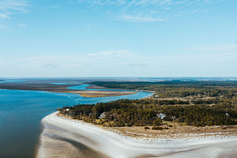
Estuaries are not all built the same way, and the Southeast contains the major types. Drowned-river-valley (or coastal-plain) estuaries form where rising sea level floods an old river valley; the Chesapeake Bay — the largest estuary in the United States — and Delaware Bay are the classic examples, deep, branching, and fed by big rivers. Bar-built estuaries form where barrier islands and sandbars enclose a shallow lagoon behind them; these are the dominant form along the Gulf coast of Texas and Florida, but they are not a Gulf monopoly — the Outer Banks of North Carolina enclose Pamlico Sound, the largest lagoon on the U.S. East Coast and a textbook bar-built estuary. And along the Georgia-Carolina coast — the South Atlantic, or Georgia, Bight — the dominant form is a vast tidal-creek-and-salt-marsh mosaic, a maze of meandering creeks that drain and fill enormous marsh plains twice a day. At the far southern, dry end of the Gulf sits the outlier: the Texas Laguna Madre, one of only a handful of hypersaline lagoons on Earth, where evaporation outruns rainfall and the water is saltier than the sea.
Three physical forces shape all of them. The first is the salinity gradient — the transition from fresh river water at the head to full seawater at the mouth — which sorts plants and animals along the estuary and creates the brackish middle ground where estuarine specialists thrive. The second is tidal range, which varies enormously across the region: most of the Gulf is microtidal, with tides under a foot or two, while the central Georgia coast has the highest tides in the Southeast, sweeping six to nine feet up the marsh and back twice a day. The third is freshwater inflow — the volume and timing of river water — which sets the salinity, delivers the sediment and nutrients, and drives the seasonal pulses the whole system is tuned to. Together, they generate the habitat heterogeneity that makes estuaries so diverse: change the salinity, the tide, or the inflow, and you change which marsh grass, which seagrass, and which animals you find.
The Living Habitats: Marsh, Mangrove, Seagrass, and Oyster Reef
Four habitats build most of the structure. The salt marsh is the signature of the Atlantic and northern Gulf coast — great meadows of cordgrass and needlerush flooding and draining with the tide, the most extensive of them along the Georgia-Carolina coast. Moving south and, increasingly, north with warming winters, the marsh gives way to mangrove: the black mangrove (Avicennia germinans), the cold-hardiest of the group, is in documented expansion up the Gulf and Atlantic coasts of Florida and beyond, encroaching into salt marsh where hard freezes no longer reliably kill it back — one of the clearest fingerprints of a warming coast, though episodic deep freezes still knock it back periodically.
Beneath the water are the other two. Seagrass meadows — underwater flowering plants, not algae — carpet the clearer shallows and sort by climate: turtle grass (Thalassia testudinum) dominates the tropical waters of South Florida and the Gulf, reaching its northern limit near Cape Canaveral; eelgrass (Zostera marina), a temperate species, is the seagrass of the Chesapeake and the coldest Atlantic water, at its southern limit near North Carolina; and shoal grass (Halodule wrightii), the most widely distributed of all, spans the Atlantic coast as far north as the Carolinas and west across the Gulf to Texas. And the oyster reef — built by the Eastern oyster (Crassostrea virginica) cementing generation onto generation — is the estuary's coral analog: hard, three-dimensional, living habitat that shelters fish and crabs, stabilizes the shoreline (the basis of the 'living shoreline' restoration movement), and filters the water. A single oyster can filter up to about fifty gallons of water a day at its peak — a maximum rate under warm, ideal conditions; the everyday rate is lower and falls off in cold water — and a healthy reef of them measurably clears an estuary.
The Keystone Complex and the Nursery
A handful of species do the ecological heavy lifting. At the top of the inshore food web sits a predator guild every Southeastern angler knows — the spotted seatrout, the red drum (redfish), and the southern flounder — the resident apex predators of the marsh and grass flats. Below them, the blue crab (Callinectes sapidus) is the estuary's central benthic omnivore, at once predator, scavenger, and prey, linking the detrital base to the fish above and supporting one of the most valuable fisheries on the coast. These are the animals whose abundance signals the health of the whole system.
Two more species define how the estuary works. The Eastern oyster, beyond its filtration, is a foundation species — its reefs are habitat that other animals cannot live without. And the penaeid shrimp — white, brown, and pink — are the great energy conveyors: they spawn offshore, their larvae ride the tides into the marsh nursery to grow through the summer on the detrital bounty, and they return to the open Gulf as adults, physically carrying the marsh's productivity out to sea and into the commercial catch. That movement is the clearest illustration of the estuary's defining role, the nursery function: the protected, food-rich shallows where juvenile fish and shellfish grow up. The numbers are stark. Most of the commercially and recreationally important species of the Southeast and Gulf — commonly cited at three-quarters or more — depend on estuaries for at least part of their life cycle, and more than ninety-five percent of the Gulf of Mexico's commercial fishery harvest is made up of estuarine-dependent species. Lose the estuary, and you lose the fishery.
Threats and Management
The estuary's location — at the bottom of the watershed, against the most desirable real estate on the continent — is also its vulnerability. Coastal development and the impervious surfaces that come with it (roads, roofs, parking lots) accelerate polluted stormwater into the water and outright erase the marsh and shellfish bottom. The larger chemical threat is nutrient loading: nitrogen and phosphorus from farms, lawns, and sewage feed algal blooms that, as they decompose, strip oxygen from the water, creating hypoxic 'dead zones.' The most famous of these — the Gulf of Mexico dead zone off Louisiana — is worth understanding precisely: it is an offshore, continental-shelf phenomenon driven by the nutrient load of the Mississippi and Atchafalaya Rivers, not an inshore estuary feature, though smaller hypoxic events do occur inside estuaries (the Chesapeake's summer dead zone, the Mobile Bay 'jubilees' that drive fish and crabs to the shore). In the Gulf, a separate biological hazard recurs: red tide, blooms of the toxic dinoflagellate Karenia brevis, most prevalent off southwest Florida but capable of running the Gulf coast and around to the Atlantic, killing fish and fouling the air.
The animals are managed across a jurisdictional seam. The states govern the inshore waters — generally out to three nautical miles, or nine along the Gulf coast of Florida and Texas — while federal authority takes over offshore to the edge of the exclusive economic zone, with the Atlantic States and Gulf States Marine Fisheries Commissions coordinating across state lines. The everyday tools are slot limits (allowing harvest only of fish within a size window, to protect both juveniles and big breeders) and seasonal closures. Those rules are tightening in places: a 2024 coastwide red drum stock assessment found the southern stock in trouble, and several Southeastern states have moved to cut red drum and spotted seatrout limits in response — South Carolina's reductions taking effect in 2026 are a current example. Specific size and creel limits change frequently and by state; anyone fishing should confirm the current regulations of the relevant agency.
The habitats themselves are under pressure and, increasingly, under repair. Roughly eighty-five percent of the world's oyster reefs have been lost to overharvest, disease, and degraded water — one of the largest losses of any marine habitat — which is why oyster-reef and living-shoreline restoration has become one of the most active fields in coastal conservation. Seagrass, a sensitive indicator of water clarity, declined sharply through the late twentieth century, though loss has slowed and some meadows have stabilized or recovered since around 2000. The cost of getting it wrong was written large in Florida's Indian River Lagoon, where nutrient-driven algal blooms killed off tens of square miles of seagrass and triggered a manatee starvation crisis that prompted an official Unusual Mortality Event — a die-off that was declared over in 2025 as the grass began to return. The throughline of estuary management is that these systems are productive beyond almost any other, but they sit downhill from everything, and keeping them requires managing the whole watershed, not just the water's edge.
Key Takeaways
Southeastern estuaries — from the Chesapeake to the Laguna Madre, along more than 30,000 miles of tidal shoreline — are among the most productive ecosystems on Earth, with net primary productivity that rivals tropical rainforest and carbon-burial rates many times those of a forest.
They run on a detrital food web: salt-marsh cordgrass and needlerush die, decompose into detritus, and fuel the invertebrate base that supports the fish, crabs, and shrimp — with mud-surface algae and phytoplankton contributing as well. The region holds all the major estuary types — drowned river valleys (the Chesapeake), bar-built lagoons (Pamlico Sound and the Gulf), and the Georgia-Carolina marsh mosaic — sorted by salinity, tidal range, and freshwater inflow.
The estuary is the coast's nursery. A predator guild of seatrout, red drum, and flounder, the blue crab, the reef-building and water-filtering Eastern oyster, and the marsh-to-sea penaeid shrimp run the system, and most of the region's fish and shellfish — more than ninety-five percent of the Gulf's commercial harvest — depend on estuaries to grow up.
The threats are development, nutrient loading and hypoxia (the Gulf dead zone is an offshore phenomenon driven by river nutrients, distinct from in-estuary hypoxia), red tide, and habitat loss — roughly 85 percent of the world's oyster reefs are gone, and seagrass remains sensitive. Management splits between state inshore and federal offshore jurisdiction, with slot limits and seasonal closures tightening as stocks like red drum decline. Confirm current state regulations before fishing.
Frequently Asked Questions
Why are estuaries so productive?
Estuaries are among the most productive ecosystems on Earth because they combine three things: abundant nutrients (delivered by rivers and recycled by the tide), shallow sunlit water, and a mix of highly productive plants — salt-marsh grasses, seagrasses, mud-surface algae, and phytoplankton. Their net primary productivity per acre rivals that of a tropical rainforest and exceeds that of most grasslands and croplands. Crucially, much of that plant material is not eaten alive but decomposes into detritus, which fuels a food web of invertebrates, fish, crabs, and shrimp. The wetlands are also major 'blue carbon' sinks, burying carbon far faster than a forest.
What are the main types of estuaries in the Southeast?
Three overlapping geomorphic types dominate. Drowned-river-valley (coastal-plain) estuaries form where the sea floods old river valleys — the Chesapeake Bay, the largest estuary in the United States, is the classic example. Bar-built estuaries are shallow lagoons enclosed by barrier islands; they are common on the Gulf coast but also on the Atlantic — North Carolina's Pamlico Sound, behind the Outer Banks, is the largest lagoon on the U.S. East Coast. And the Georgia-Carolina coast (the South Atlantic Bight) is a vast tidal-creek-and-salt-marsh mosaic with the region's highest tides. The Texas Laguna Madre, a rare hypersaline lagoon, anchors the dry western end.
What is a salt marsh, and how does it feed the food web?
A salt marsh is a tidal wetland dominated by salt-tolerant grasses — smooth cordgrass (Spartina alterniflora) in the regularly flooded low marsh and black needlerush (Juncus roemerianus) in the higher marsh. Most of that grass is not grazed alive; it dies back and is broken down by bacteria and fungi into detritus, which is the base of the food web. That detritus feeds amphipods, fiddler crabs, marsh snails, shrimp, and small fish, which feed everything larger — the 'outwelling' or detritus paradigm developed on the Georgia marshes. Mud-surface algae and phytoplankton also contribute, but the marsh's decomposition-driven base is what makes it so productive.
Why do oyster reefs matter, and do oysters really filter the water?
Oyster reefs are the estuary's coral analog — hard, three-dimensional living habitat built by the Eastern oyster (Crassostrea virginica) cementing generation onto generation. They shelter fish and crabs, stabilize shorelines (the basis of 'living shoreline' restoration), and filter the water. A single oyster can filter up to about fifty gallons a day, but that is a maximum under warm, ideal conditions; the everyday rate is lower and drops off sharply in cold water. Even so, a healthy reef measurably clears an estuary. Oysters are a foundation species, which is why their loss — roughly 85 percent of the world's oyster reefs are gone — matters so much, and why reef restoration is a major focus of coastal conservation.
What is the estuary 'nursery,' and which species depend on it?
The 'nursery function' is the estuary's role as a protected, food-rich shallow-water habitat where the larvae and juveniles of coastal species grow up before moving to open water. The penaeid shrimp (white, brown, pink) are the classic example: they spawn offshore, their young use the marsh nursery through the summer, and they return to the Gulf as adults. The dependence is enormous — roughly three-quarters or more of the commercially and recreationally important species of the Southeast and Gulf rely on estuaries for at least part of their life cycle, and more than ninety-five percent of the Gulf of Mexico's commercial fishery harvest is made up of estuarine-dependent species. Lose the estuary and you lose the fishery.
What seagrasses grow in the Southeast?
Three main seagrasses are sorted by climate. Turtle grass (Thalassia testudinum) is the dominant tropical species of South Florida and the Gulf, reaching its northern Atlantic limit near Cape Canaveral. Eelgrass (Zostera marina) is a temperate species — the seagrass of the Chesapeake Bay and the colder Atlantic water — at its southern limit near North Carolina. Shoal grass (Halodule wrightii) is the most widely distributed of the three, ranging up the Atlantic coast to the Carolinas and west across the Gulf to Texas. Seagrass meadows are sensitive indicators of water clarity, provide critical nursery habitat, and store 'blue carbon'; they declined sharply in the late twentieth century, with partial recovery in some areas since about 2000.
What is the Gulf 'dead zone,' and is it in the estuaries?
The Gulf of Mexico 'dead zone' is a large area of low-oxygen (hypoxic) water that forms each summer on the continental shelf off Louisiana. It is an offshore phenomenon, driven by the heavy nutrient load carried by the Mississippi and Atchafalaya Rivers from the farmland of the Midwest: the nutrients fuel algal blooms whose decomposition consumes oxygen. It is not, strictly, an inshore estuary feature — though smaller hypoxic events do occur inside estuaries, such as the Chesapeake Bay's summer dead zone and the Mobile Bay 'jubilees' that push fish and crabs to the shore in search of oxygen. The common thread is nutrient loading, which is the central water-quality challenge facing estuaries and coastal seas alike.
What are the biggest threats to southeastern estuaries?
The main threats are coastal development and stormwater runoff (which destroy habitat and degrade water quality), nutrient loading and the hypoxia it causes, harmful algal blooms such as Gulf red tide (Karenia brevis), and outright habitat loss — roughly 85 percent of the world's oyster reefs are gone, and seagrass remains vulnerable, as Florida's Indian River Lagoon seagrass die-off and resulting manatee crisis showed. Because estuaries sit at the bottom of their watersheds, protecting them means managing the whole watershed. On the fisheries side, states manage inshore waters with tools like slot limits and seasonal closures, which are tightening as stocks such as red drum decline; confirm current state regulations before fishing.
Citations and Sources
This synthesis draws on the federal agencies, state agencies, and research institutions below. Fisheries size and creel limits and seasons change frequently and by state — verify current rules directly with the relevant agency before fishing.
Federal and interstate sources
NOAA — the National Ocean Service Estuaries Tutorial, the National Estuarine Research Reserve System, the Office for Coastal Management shoreline-mileage data, and NOAA Fisheries on estuarine-dependent species and the Gulf hypoxic zone.
U.S. Environmental Protection Agency — the National Estuary Program and nutrient-pollution and hypoxia science.
U.S. Geological Survey — estuarine and coastal hydrology and water-quality monitoring.
Atlantic States Marine Fisheries Commission and Gulf States Marine Fisheries Commission — interstate stock assessments (including the 2024 red drum benchmark assessment) and the inshore fisheries-management framework.
State marine and natural-resource agencies
The Virginia Marine Resources Commission and Virginia Institute of Marine Science, North Carolina Division of Marine Fisheries, South Carolina DNR, Georgia DNR Coastal Resources Division, the Florida Fish and Wildlife Conservation Commission (and its Fish and Wildlife Research Institute), the Alabama Marine Resources Division, the Louisiana Department of Wildlife and Fisheries, and Texas Parks and Wildlife — state inshore regulations, salt-marsh and seagrass science, oyster and red tide monitoring, and the Florida manatee / Indian River Lagoon work.
Research and conservation sources
The Smithsonian Environmental Research Center and university marine labs — estuarine food-web and outwelling research (building on the classic Odum and Teal Georgia salt-marsh studies); McLeod et al. (2011) on blue-carbon burial rates; and Beck et al. (2011) / The Nature Conservancy on the ~85 percent global loss of oyster reefs.
Confidence note: Estuaries are 'among the most productive ecosystems on Earth' — a defensible, sourced phrasing; avoid the unqualified 'the most productive marine ecosystem.' The productivity point concerns net primary productivity per unit area (which rivals tropical rainforest and exceeds most grasslands and croplands), not standing 'biomass'; carbon-burial rates run many times higher than terrestrial forest. '30,000+ miles of tidal shoreline' refers to NOAA shoreline mileage including bays, sounds, and tidal creeks (about 35,000+ miles for the SE Atlantic and Gulf), not the much shorter 'general coastline.' A single oyster's '~50 gallons per day' is a maximum under ideal conditions; typical wild rates are lower and temperature-dependent. Bar-built estuaries occur on both the Gulf and the NC/SC Atlantic (Pamlico Sound), not the Gulf alone. The Gulf hypoxic 'dead zone' is an offshore, Mississippi-River-driven feature, distinct from in-estuary hypoxia. Estuarine-dependence figures (~75%+ of important species; >95% of Gulf commercial harvest) and the ~85% oyster-reef loss are widely cited agency and peer-reviewed figures. All fisheries limits, seasons, and the status of events like the Florida manatee Unusual Mortality Event (declared over in 2025) change — verify current status with the relevant agency.
Explore More
This synthesis is part of Pine & Marsh's ecology-first series on the Southeastern outdoors. The companion syntheses and the coastal and estuary field reports below go deeper on the marshes, sounds, and deltas the inshore system runs through.


Comments