
Bobwhite Quail: Ecology, Habitat Decline, and the Longleaf Pine Connection
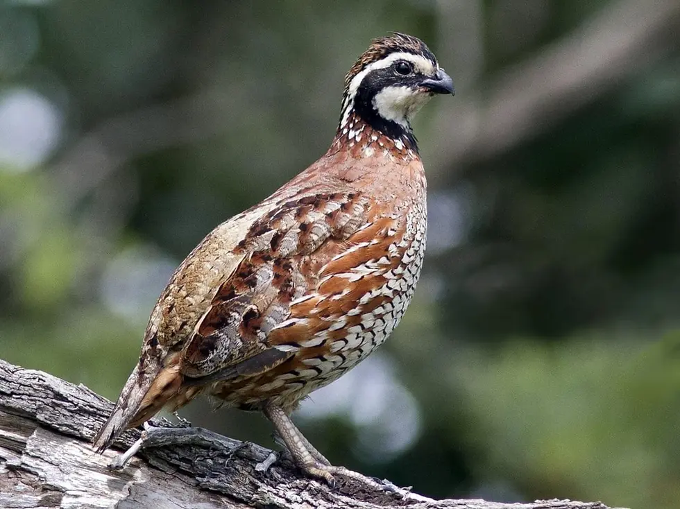
There is a sound that used to define the rural South. Not the mourning dove's coo or the gobble of a spring tom -- those persist, diminished but present. The sound was a two-note rising whistle, clean and unmistakable, carrying across cotton fields and pine flats and split-rail fencerows from the Virginia Piedmont to the Louisiana parishes: bob-WHITE. It gave the bird its name, and for most of the 20th century, it gave the southeastern landscape its acoustic signature. That sound is disappearing from the region at a rate that the data can now measure precisely, and the measurement is alarming.
The Northern Bobwhite (Colinus virginianus) has declined by approximately 85 percent across its range since 1966, according to the U.S. Geological Survey's Breeding Bird Survey -- the longest-running and most comprehensive avian population monitoring program in North America. In absolute terms, the BBS estimates that the southeastern and eastern bobwhite population fell from roughly 31 million birds in the mid-1960s to fewer than 5.5 million by 2019. That is a loss of more than 25 million individual quail from a region that stretches from the Chesapeake Bay to the Gulf Coast, from the Appalachian foothills to the Texas Cross Timbers. No other upland game bird in the eastern United States has sustained a decline of this magnitude over this period.
This is not a story about overhunting. Bobwhite harvest has declined in lockstep with populations across every southeastern state -- fewer birds producing fewer hunters producing fewer days afield -- and the harvest rate on most public and private land falls well below the biological surplus that a healthy population can sustain. This is a habitat story. And it tracks, with a precision that would satisfy any ecologist, the collapse of the fire-maintained grassland-savanna ecosystem that once defined the upland South. Where that system persists -- on the managed quail plantations of the Georgia-Florida Red Hills, on the prescribed-fire units of the Talladega and Oakmulgee in Alabama, on private lands across the longleaf belt from the Carolinas to Mississippi where fire is still applied on a one-to-three-year rotation -- bobwhite persist at densities that would have been unremarkable in 1960. Where it has been lost, the bird is functionally gone.
A Life History Built for Loss
Understanding why the bobwhite is so vulnerable to habitat change -- and why it can recover so rapidly when habitat is restored -- requires understanding a life-history strategy that is, by any standard, one of the most extreme in North American ornithology. The bobwhite is a bird built to die. Annual survival rates for adults run between 15 and 20 percent, meaning that 80 to 85 percent of the birds alive in a given October will not survive to the following October. Hawks take them from above -- Cooper's hawks and red-tailed hawks during the day, great horned owls at dusk and dawn. Foxes, bobcats, rat snakes, and fire ants take them on the ground. Winter cold snaps kill exposed coveys in a single night. This is not pathological. It is the species' evolutionary baseline, and it has been the baseline for thousands of years across the southeastern Coastal Plain.
The compensation is reproductive. A bobwhite hen lays 12 to 16 eggs per clutch -- among the largest clutch sizes of any North American game bird. If the nest is destroyed by a predator or a tractor or a prescribed burn timed too late, she will renest, sometimes two or three times in a single season. In favorable years, hens occasionally double-clutch: laying a second clutch for the male to incubate while she initiates a third. This fecundity makes the bobwhite a boom-or-bust species. In years with adequate April and May rainfall to produce the insect biomass that chicks require, combined with open ground structure that allows chick mobility at the 2-to-4-inch height where they live for their first three weeks, populations can rebound dramatically within a single breeding season. A well-managed property in the Red Hills of South Georgia can swing from 1.5 birds per acre in a poor year to 3.5 in a good one.
The covey is the fundamental social unit. From late autumn through early spring, bobwhite in the Southeast live in groups of 8 to 25 birds that roost together on the ground each night in a tight circle, tails inward, heads facing outward. This formation serves two functions simultaneously: thermoregulation (shared body heat reduces metabolic cost during cold southeastern nights, which still routinely drop below freezing from Virginia through the northern Gulf states) and predator detection (the outward-facing heads provide 360-degree surveillance). Research from the University of Georgia's Warnell School and Tall Timbers Research Station in Tallahassee has demonstrated that coveys below roughly 8 birds experience disproportionate winter mortality because the thermal benefit of communal roosting breaks down at that threshold. A fragmented landscape that isolates small groups of 4 or 5 birds is killing quail through physics as much as predation.
What the Bird Actually Needs: Habitat Requirements in the Southeastern Context
The bobwhite is a ground bird in the fullest sense. It nests on the ground, feeds on the ground, roosts on the ground, and spends its entire life cycle -- birth to death, typically within a single calendar year -- on roughly 40 acres of habitat. It does not migrate. It does not use forest canopy. It cannot tolerate dense ground cover that impedes movement at chick height. Every management principle for bobwhite habitat in the Southeast reduces to a single imperative: maintain open, structurally diverse ground cover with bare soil, native bunchgrass, and forb diversity in a mosaic of scattered woody cover that provides overhead concealment from the raptors that are the species' primary daytime predators.
Nesting cover in the southeastern states means native bunchgrasses -- wiregrass (Aristida stricta in the Carolinas and Virginia, A. beyrichiana from Georgia south and west), little bluestem (Schizachyrium scoparium), and broomsedge bluestem (Andropogon virginicus). These grasses form dense clumps at the base while leaving open space between tufts -- the structural architecture within which a hen builds her nest, concealed from above by arching grass blades. Sod-forming grasses are the enemy. Tall fescue (Schedonorus arundinaceus) and bermudagrass (Cynodon dactylon), the two most widely planted forage grasses across the upper South, form a continuous mat at ground level that a bobwhite cannot penetrate to build a nest and that provides none of the structural concealment the species requires.
But it is brood habitat -- the cover type required by chicks during their first 14 to 21 days of life -- that is the most critical and most commonly deficient component on the modern southeastern landscape. Bobwhite chicks are precocial. They leave the nest within hours of hatching and must feed themselves immediately. Their diet for the first two weeks is almost exclusively invertebrates -- beetles, grasshoppers, spiders, caterpillars, native ants -- providing the protein required for feather development and the thermoregulation that downy chicks cannot yet achieve on their own. These chicks move through the habitat on foot, at ground level, at a height of 2 to 4 inches. They require bare ground -- greater than 30 percent of the surface area -- interspersed with forb-rich vegetation that produces insect biomass. If the ground is too dense for the chicks to walk through, or too monocultural to support diverse insect communities, brood survival collapses regardless of how many nests successfully hatch.
This bare-ground requirement is the single most important variable in southeastern bobwhite management, and it is the one most consistently absent from the modern landscape. Decades of converging research -- from Tall Timbers in the Florida panhandle, the Albany Quail Project in southwest Georgia, Auburn University in the Alabama Piedmont, Mississippi State in the Piney Woods, and cooperative wildlife research units from Virginia to Louisiana -- has produced a consistent finding: bobwhite density correlates more strongly with bare-ground availability than with any other measurable habitat variable. Properties that maintain 30 to 50 percent bare ground through prescribed fire and periodic disking consistently support 1 to 3 birds per acre. Properties with less than 15 percent bare ground -- the typical condition on ungrazed fescue pasture, CRP switchgrass monocultures, or fire-suppressed loblolly stands across the Piedmont and upper Coastal Plain -- support functionally zero bobwhite, regardless of what the surrounding landscape looks like.
Ninety Million Acres Lost: The Longleaf Pine Connection
The Northern Bobwhite evolved in a landscape that no longer exists at scale anywhere in the southeastern United States. The longleaf pine savanna -- approximately 90 million acres stretching from southeastern Virginia through the Carolinas, Georgia, Florida, Alabama, Mississippi, and Louisiana to eastern Texas -- was the dominant upland ecosystem of the southeastern Coastal Plain for at least 8,000 years. It was maintained by lightning-ignited fire that swept through the understory every one to three years during the late-spring and early-summer thunderstorm season, producing exactly the habitat structure that bobwhite require: an open, park-like canopy of widely spaced pines with 40 to 80 percent light penetration to the forest floor; a diverse ground layer of wiregrass, native forbs, and legumes producing both seed and insect biomass year-round; bare mineral soil exposed by the passage of fire; and scattered thickets of gallberry, Vaccinium, and Rubus providing escape cover from the sharp-shinned and Cooper's hawks that patrol the savanna edge.
Today, longleaf pine-dominated forests cover approximately 5 to 5.5 million acres across the Southeast -- a reduction of more than 93 percent from their historical extent. Of that remnant, only about 12,000 highly fragmented acres qualify as mature old-growth. The America's Longleaf Restoration Initiative, which coordinates more than 75 partner organizations across nine southeastern states, has reversed the acreage trend since 2010, expanding the longleaf footprint from roughly 3 million to nearly 5.5 million acres through replanting and fire restoration. That is a genuine conservation achievement. But the gap between 5.5 million and 90 million frames the magnitude of what the Southeast lost in the space of a century and a half, and the correlation between longleaf decline and bobwhite decline is not coincidental. It is causal, documented across multiple spatial scales, and consistent in every southeastern state where the data exist.
The primary agent of longleaf loss across the southeastern Coastal Plain was conversion to loblolly pine (Pinus taeda) plantation. Loblolly grows faster, produces merchantable pulpwood sooner, and does not demand the labor-intensive prescribed-fire regime that longleaf requires to regenerate and persist. Southeastern timber companies and the pulp-and-paper industry planted millions of acres of loblolly from the 1940s through the 1990s at densities of 600 to 800 trees per acre -- compared to 40 to 80 per acre in a mature longleaf savanna. Within 10 to 15 years, these plantations close canopy, eliminating the understory light that native grasses and forbs require to persist. Even where loblolly is managed with fire, the stand density precludes the open ground structure bobwhite needs. The economic calculus was straightforward, and the ecological consequence was the landscape-scale substitution of bobwhite habitat with non-habitat across tens of millions of acres in the southeastern United States.
The second driver is one that fewer people outside the region know about: the aggressive promotion of tall fescue as a forage grass for cattle across the upper South. From the 1940s through the 1980s, the USDA Soil Conservation Service and state extension programs in Virginia, the Carolinas, Tennessee, Kentucky, Georgia, and Alabama encouraged the conversion of native grassland and savanna to fescue pasture on a massive scale. Fescue spread across millions of acres of former bobwhite habitat in the Piedmont and upper Coastal Plain. The result for quail was catastrophic. Fescue forms a dense, persistent sod that eliminates bare ground, suppresses native forb diversity, and harbors an endophytic fungus (Epichloë coenophiala) that is toxic to many invertebrates and reduces the insect biomass available to brooding chicks. The Piedmont and northern Coastal Plain -- where fescue conversion was most complete, from central Virginia through the Carolina foothills into northern Georgia and Alabama -- show the steepest declines in bobwhite numbers in the BBS data. The geography of fescue is the geography of bobwhite collapse.
The Fire That Matters: Growing-Season Burns and the Southeastern Understory
Prescribed fire is the primary tool for bobwhite habitat management across the Southeast, and more acreage burns under prescription in the eleven southeastern states than in any other region of the country. But not all fire is equal, and the distinction between dormant-season fire and growing-season fire is one of the most consequential findings in modern southeastern fire ecology.
Dormant-season fire -- December through February, the default prescription on most southeastern forestland -- burns through accumulated leaf litter and standing dead grass while hardwood shrubs and midstory trees are leafless and dormant. The root systems are undamaged. They resprout each spring vigorously, and over multiple cycles of dormant burning, the hardwood midstory actually thickens rather than retreats, progressively shading the ground layer and reducing the bare ground, forb diversity, and insect production that bobwhite require. Dormant-season fire is better than no fire. But on the southeastern Coastal Plain, where sweetgum, red maple, and water oak are aggressive midstory colonizers, it is an incomplete prescription for bobwhite habitat.
Growing-season fire -- burning between April and June, when hardwoods are in full leaf and actively moving carbohydrates from root reserves to canopy -- damages cambium and root systems far more severely. Research from Tall Timbers, the Jones Ecological Research Center at Ichauway in southwest Georgia, and Eglin Air Force Base in the Florida panhandle has documented that growing-season burns reduce woody stem density, increase herbaceous ground cover, stimulate the germination of native legumes (Lespedeza, Desmodium, and partridge pea -- all critical seed and insect producers for bobwhite), and increase bare-ground availability by 15 to 30 percent compared to dormant burns on the same sites. This should not be surprising. The longleaf pine ecosystem evolved with lightning fire that peaked in late spring and early summer. The historical fire season was a growing-season fire season, and the plant community is adapted to that timing. When we burn in winter, we are applying fire on a schedule the ecosystem did not evolve with.
The practical implications for land managers across the Southeast are direct. Properties that burn exclusively in the dormant season produce a gradually thickening midstory that degrades quail habitat year over year, even when the fire return interval is adequate. Properties that incorporate growing-season fire on a portion of their burn units -- rotating so that no single unit is burned during nesting season every year -- maintain the open, herbaceous-dominant ground cover the species requires. Tall Timbers and the National Bobwhite Conservation Initiative both advocate growing-season fire as a component of any serious bobwhite habitat program in the southeastern states.
The BBS Map: Where the Southeast Has Lost Its Quail
The USGS Breeding Bird Survey runs 24.5-mile roadside transects surveyed annually during the breeding season across every southeastern state. The dataset extends back to 1966 for most of the region, and it paints a geographic picture of decline that is anything but uniform.
The steepest losses have occurred in the Piedmont and northern Coastal Plain. Virginia, where bobwhite were once abundant enough to support a statewide season and a vibrant pointing-dog culture, now records fewer than 0.5 birds per BBS route on most survey transects -- a population so sparse that encountering a wild covey in the Virginia Piedmont is an event, not an expectation. The Carolinas, Tennessee, Kentucky, and northern Georgia and Alabama tell the same story: annual BBS declines of 4 to 7 percent, sustained over five decades, compounding to population reductions exceeding 90 percent. These are the landscapes where fescue conversion, fire suppression, loblolly plantation, and suburban sprawl from Charlotte to Nashville to Atlanta converged most completely.
The lower Coastal Plain tells a different story, and it is an instructive one. South Georgia's Red Hills and Albany plantation belt, North Florida's longleaf parishes, the Alabama Black Belt from Greensboro through Selma to Demopolis, the Mississippi Piney Woods from Meridian south to Hattiesburg, and the Louisiana longleaf parishes from Vernon to Washington -- these are the landscapes where wild bobwhite still persist at densities that support traditional wild-bird hunting. They are landscapes where longleaf pine or mixed pine-hardwood savanna is still managed with prescribed fire, where agriculture coexists with native groundcover rather than replacing it, and where the land-use pattern still provides the structural mosaic of open ground, bunchgrass, forb cover, and scattered shrub that the species demands. The bird is not inherently doomed. The Southeast has not crossed some irreversible ecological threshold. The bobwhite responds to habitat management with a speed and predictability that is rare among declining wildlife species. The problem is that the management it requires is labor-intensive, fire-dependent, and economically viable only where the landowner has decided that quail are a primary objective.
The National Bobwhite Conservation Initiative and the Focal Landscape Strategy
The National Bobwhite Conservation Initiative, coordinated through the National Bobwhite Technical Committee and housed at the University of Tennessee, represents the most ambitious attempt to reverse the decline at a scale that matters. NBCI operates on a focal-landscape model: instead of spreading habitat investments thin across the entire southeastern range, the initiative identifies discrete landscapes of 5,000 to 50,000 acres where existing habitat conditions, willing private landowners, and state or federal agency capacity converge to make population-level recovery achievable within a defined timeframe.
As of 2024, NBCI coordinates 27 focal landscapes across 25 states, with the highest concentration in the southeastern core range -- Georgia, Florida, Alabama, Mississippi, South Carolina, North Carolina, Virginia, Kentucky, and Tennessee. Each operates under a science-based habitat plan specifying target acreages for prescribed fire, native-grass establishment, woody-cover reduction, and field-border management. The monitoring protocol uses standardized covey-call surveys during the fall season to track population response.
The focal-landscape approach reflects a hard-won ecological insight that decades of piecemeal conservation taught the Southeast: bobwhite conservation cannot succeed at the individual-property scale unless the surrounding landscape also provides habitat. A 500-acre property managed perfectly for quail, surrounded by fescue pasture and loblolly plantation, will not sustain a viable population because the property is too small to buffer against 80-percent annual mortality. The species requires contiguous habitat connectivity measured in thousands of acres, not hundreds. The NBCI model attempts to achieve that scale by coordinating management across multiple ownerships -- national forests, state WMAs, military installations, and private land enrolled in USDA conservation programs -- within each focal landscape.
CRP, EQIP, and the Federal Policy Levers That Move Southeastern Habitat
On private land across the Southeast -- where the majority of potential bobwhite habitat exists -- the USDA's Conservation Reserve Program and Environmental Quality Incentives Program are the two most significant policy tools. CRP pays landowners an annual rental rate to retire environmentally sensitive cropland and establish perennial cover. At peak enrollment in the mid-2000s, CRP covered roughly 37 million acres nationally; as of 2024, that figure has declined to approximately 23 million acres as commodity prices have drawn acreage back into row-crop production.
The quality of CRP cover for bobwhite depends critically on the planting mix and post-enrollment management. Early CRP plantings across the southeastern states in the 1980s and 1990s often used dense monocultures of switchgrass or weeping lovegrass that grew too thick for bobwhite to use -- a well-intentioned conservation investment that produced minimal wildlife benefit because the vegetative structure was wrong. Modern CRP practices in the southeastern bobwhite states emphasize diverse native-grass and forb seed mixes at lower seeding rates, with mid-contract management (periodic disking or prescribed fire on a portion of the field every 2 to 3 years) to prevent vegetative stagnation that degrades habitat quality over a 10- to 15-year contract. CP33 -- Habitat Buffers for Upland Birds -- prescribes 30-to-120-foot native-vegetation buffers along field edges, replicating the exact field-border habitat pattern that sustains bobwhite in the working agricultural landscapes of Georgia, Alabama, and Mississippi's lower Coastal Plain.
EQIP provides cost-share for habitat management practices on working agricultural and forestland. For southeastern bobwhite, the relevant practices include prescribed burning (NRCS Practice 338), brush management (314), herbaceous weed treatment (315), and upland wildlife habitat management (645). NBCI coordinates with NRCS state offices across the Southeast to target EQIP funding toward focal landscapes where the cumulative impact of multiple cost-shared practices produces landscape-scale connectivity. The limiting factor is rarely the availability of federal dollars. It is the availability of southeastern landowners willing to put fire back on the ground that has not been burned in decades.
The Plantation Belt: Where the Southeast Still Has Its Quail
Drive south from Albany, Georgia, toward Thomasville and across the Florida line toward Tallahassee, and you enter a landscape that exists nowhere else in the American South. The Red Hills -- 70 to 80 privately owned quail plantations ranging from 2,000 to over 10,000 acres each, collectively encompassing roughly 300,000 acres of longleaf and shortleaf pine savanna -- represent the most intensively managed fire-dependent ecosystem in the eastern United States. These properties burn on an annual or biennial rotation. They supplement fire with strip-disking, selective hardwood removal, and the kind of ground-level habitat management that has been refined over a century of continuous practice. Wild quail densities on well-managed Red Hills properties consistently run 2 to 4 birds per acre -- population levels essentially unchanged from the historical baseline, while the landscapes surrounding them have lost 85 percent or more of their bobwhite.
The Red Hills are proof of concept. They demonstrate that the bobwhite's decline is not an inevitable consequence of modernity, a shifting climate, or an irreversible ecological transition. It is a direct consequence of habitat loss and fire suppression, and it is reversible where the commitment exists. Tall Timbers Research Station, located within the Red Hills landscape, has spent more than six decades producing the fire ecology and quail management research that underpins this system -- work that began with Herbert L. Stoddard's 1931 monograph, The Bobwhite Quail, which remains the foundational text in upland game management.
Other southeastern strongholds follow the same pattern. The South Carolina Lowcountry from the ACE Basin through the Santee corridor carries a parallel tradition of managed quail habitat on large private properties, though development pressure is more intense. Alabama's Black Belt -- the dark, fertile soils stretching from Greensboro through Selma to Demopolis -- supports wild quail on properties where fire and native groundcover persist. Mississippi's Piney Woods from Meridian south, and Louisiana's Vernon and Beauregard parish longleaf tracts, represent additional landscapes where the bird holds. In every case, the common factor is fire. Frequent, intentional, prescribed burning that maintains the open ground structure the species evolved to occupy in the southeastern Coastal Plain.
The Indicator Species: What the Bobwhite Tells Us About the Southeastern Landscape
The bobwhite is not declining alone. It is declining alongside a guild of grassland and early-successional species that depend on the same fire-maintained southeastern landscape: the Eastern meadowlark (BBS decline of approximately 75 percent since 1966), the loggerhead shrike (approximately 76 percent), the field sparrow (approximately 68 percent), the Bachman's sparrow (one of the most rapidly declining passerines in the Southeast, now functionally absent from most of its former Piedmont range), the common nighthawk, the red-headed woodpecker, and the prairie warbler. The BBS data for grassland-obligate birds across the eastern United States tell a single, consistent story: the entire guild adapted to open, fire-maintained ground cover is collapsing as that cover type vanishes from the southeastern landscape.
This is why ecologists across the region describe the bobwhite as an indicator species -- a term that carries specific and consequential meaning. The bobwhite's population status indexes the health of an entire southeastern ecosystem type. Managing for bobwhite does not produce a landscape that benefits only bobwhite. It produces a landscape that benefits the gopher tortoise (a keystone burrowing species whose burrows shelter more than 350 commensal species across the southeastern Coastal Plain), the red-cockaded woodpecker (federally listed, dependent on mature longleaf with an open understory), the Eastern indigo snake, the Carolina gopher frog, and the full suite of native invertebrates -- ground-nesting bees, beetles, butterflies, grasshoppers -- that depend on the herbaceous ground layer that fire maintains.
The red-cockaded woodpecker recovery on Eglin Air Force Base in the Florida Panhandle illustrates this relationship with particular clarity. Eglin manages approximately 380,000 acres of longleaf pine under a growing-season fire program that is one of the largest in the Southeast. The same regime that sustains the base's federally listed woodpecker population -- open longleaf savanna with frequent fire and diverse herbaceous understory -- also supports one of the highest wild bobwhite densities on any publicly managed land east of the Mississippi. The two species require the same ecosystem. Managing for one produces habitat for the other, and for dozens of additional species that no one is tracking with the same intensity.
The Fire Ant and the Pen-Raised Bird: What Doesn't Explain the Decline
Two explanations for the bobwhite decline circulate widely in the southeastern sporting community, and both deserve honest assessment. The red imported fire ant (Solenopsis invicta), introduced to Mobile, Alabama, from South America in the 1930s and now established across the entire southeastern Coastal Plain, is a documented predator of bobwhite eggs and newly hatched chicks. Research from Texas A&M and the Southeast Quail Study Group confirms that fire ants can reduce nest success by 10 to 20 percent in areas with high mound density, and they depress the native invertebrate biomass that chicks depend on.
But the geographic and temporal pattern of the decline does not align with fire-ant expansion. Bobwhite populations crashed in parts of the Southeast where fire ants were not yet established, and the decline has been steepest in the Piedmont -- the northern edge of the fire-ant range -- rather than in the lower Coastal Plain where fire-ant densities are highest. The Red Hills plantations of South Georgia, fully within fire-ant territory, sustain 2 to 4 birds per acre. The explanation is habitat quality: on landscapes with abundant bare ground and diverse forb cover, bobwhite reproductive output is high enough to absorb fire-ant predation and still produce a surplus. In degraded habitat where reproduction is already suppressed, fire ants become an additional source of mortality that the population cannot sustain. Fire ants are a real factor, but they are secondary, layered on top of the primary driver.
As for pen-raised birds -- the most common and least effective response to declining wild populations across the southeastern states -- the peer-reviewed literature is unequivocal. Pen-raised bobwhites do not survive at ecologically meaningful rates, do not integrate into wild coveys, do not reproduce successfully, and do not contribute to population recovery. Research from the University of Georgia, Auburn, Mississippi State, and multiple state agencies documents 5 to 10 percent survival within 30 days of release, compared to roughly 50 percent for wild birds over the same period. Pen-raised quail lack predator-avoidance behavior, carry higher parasite loads, and are genetically selected for docility rather than the survival traits wild bobwhite require. Every major quail research institution in the Southeast has formally concluded that every dollar spent on stocking would produce greater conservation return if redirected to habitat management.
What Recovery Requires Across the Southeastern States
Reversing the bobwhite decline in the Southeast is not a mystery. The species' requirements are documented beyond any reasonable dispute, the management tools are proven, and the demonstration sites -- from the Red Hills to Eglin to the NBCI focal landscapes scattered across nine southeastern states -- show that population recovery follows habitat restoration with rare predictability. The challenge is not ecological. It is one of scale, economics, and political will.
Three elements define the most promising path forward. First, expansion of prescribed fire across the Southeast. The region already burns more acres under prescription than any other in the country, but the total remains a fraction of the historical fire footprint. Regulatory barriers -- smoke management rules written for industrial point sources rather than ecological burns, liability frameworks that penalize prescribed burners for smoke incidents that would occur naturally from lightning, and a chronic shortage of trained burn crews -- limit the application of the single most effective habitat tool. Second, strategic targeting of USDA conservation dollars toward NBCI focal landscapes, ensuring that CRP and EQIP investments are concentrated where their cumulative effect produces landscape-scale habitat connectivity rather than isolated patches in a matrix of non-habitat. Third, conversion of fescue pasture to native warm-season grasses across the upper South -- a practice that simultaneously improves summer cattle forage, eliminates fertilizer inputs, and restores bobwhite habitat on millions of acres of Piedmont and upper Coastal Plain that the species has already abandoned.
The Northern Bobwhite is not yet a candidate for federal listing under the Endangered Species Act, though its population trajectory would qualify in many portions of its southeastern range. Whether listing would help or hinder recovery is debated -- the regulatory burden could discourage the private landowner participation that any landscape-scale recovery requires. What is not debated is the trajectory. Without a significant increase in the scale of habitat management across the eleven southeastern states where the species' strongholds persist, the bobwhite will continue to decline toward functional extirpation across most of its historical range, surviving only on managed plantations and focal landscapes where fire and investment sustain it.
The bobwhite's 85-percent decline is not a footnote in southeastern ecology. It is the central diagnostic. This is the species that told you whether the land was healthy -- whether the fire had been through, whether the understory was open, whether the ground still grew the grasses and forbs and insects that a web of species depended on. Where fire persists in the southeastern Coastal Plain, the bird persists. Where fire has been suppressed, the bobwhite is a memory. And the landscape it leaves behind is quieter, denser, and less alive than the one it evolved in.
Explore More
This post is part of Pine & Marsh's ecology blog -- a long-form editorial series covering the ecology of every species, habitat, and conservation story across the eleven southeastern states we report on.
Full Citations and Sources
The following agencies, institutions, and research inform the ecological, population, and conservation context in this report.
Government and agency sources
U.S. Geological Survey, Breeding Bird Survey -- range-wide bobwhite population trend data, 1966–present; annual indices and credible intervals by state and Bird Conservation Region across the southeastern United States
U.S. Fish and Wildlife Service -- longleaf pine ecosystem conservation, red-cockaded woodpecker and gopher tortoise critical habitat, national wildlife refuge management across the southeastern Coastal Plain
USDA Natural Resources Conservation Service -- Conservation Reserve Program enrollment data (southeastern states), EQIP practice standards (338, 314, 315, 645), CP33 and CP38 specifications for upland bird habitat in the South
U.S. Forest Service -- Talladega National Forest and Oakmulgee Ranger District prescribed-fire programs (Alabama), longleaf pine restoration targets across southeastern national forests
U.S. Department of Defense, Eglin Air Force Base (Florida panhandle) -- longleaf pine and prescribed-fire management on 380,000 acres, red-cockaded woodpecker and bobwhite monitoring programs
Research, conservation, and institutional sources
Tall Timbers Research Station (Tallahassee, Florida) -- fire ecology, bobwhite population dynamics, growing-season vs dormant-season fire research; Herbert L. Stoddard's foundational 1931 monograph The Bobwhite Quail
Joseph W. Jones Ecological Research Center at Ichauway (Baker County, Georgia) -- longleaf pine ecosystem science, prescribed-fire ecology, bobwhite habitat research in the southwest Georgia Coastal Plain
National Bobwhite Conservation Initiative, University of Tennessee -- focal landscape strategy, covey-call monitoring protocols, range-wide conservation planning across 25 states
America's Longleaf Restoration Initiative -- historical and current longleaf acreage across nine southeastern states, restoration targets, partner coordination
Southeast Quail Study Group -- multi-state bobwhite research coordination, fire-ant impact studies, pen-raised release evaluations across the southeastern range
University of Georgia Warnell School of Forestry and Natural Resources -- covey dynamics, thermal ecology, habitat-selection research in the Georgia Piedmont and Coastal Plain
Auburn University School of Forestry and Wildlife Sciences -- pen-raised quail survival studies, habitat management on working lands in the Alabama Black Belt and Piedmont
Mississippi State University Forest and Wildlife Research Center -- bobwhite response to CRP enrollment, native-grass establishment, fire effects monitoring in the Mississippi Piney Woods and Delta
Texas A&M University Department of Rangeland, Wildlife, and Fisheries Management -- red imported fire ant predation on bobwhite, Rolling Plains quail research (western range context)
Albany Quail Project (southwest Georgia) -- long-term population monitoring and habitat management research in the Red Hills plantation belt
The Longleaf Alliance -- ecosystem restoration standards, prescribed-fire advocacy, longleaf planting and management guidance across the southeastern longleaf range
Confidence note: Population estimates and BBS trend data cited in this report reflect the most recent publicly available analyses from the USGS Breeding Bird Survey (1966–2019 dataset). The 85-percent range-wide decline figure is the commonly published estimate; annual indices and credible intervals vary by state and analysis method. Longleaf pine acreage figures reflect ALRI's most recent range-wide assessment across nine southeastern states. CRP enrollment data reflect USDA Farm Service Agency reports through fiscal year 2024. Research findings and management prescriptions are attributed to the southeastern institutions that produced them.


Comments