
Okefenokee and the Coastal Georgia Field Report: Blackwater Swamp Ecology, the Altamaha, and the Tidewater Sporting Coast

There is a line on the map of southeast Georgia that most visitors never notice, but every guide down here can draw it from memory. It runs from the peat-choked interior of the Okefenokee, out along the blackwater rivers it feeds, down through the pine flats and rice-field remnants of the coastal plain, and finally into the salt of the Atlantic estuary. It is not a single river system or a single habitat type. It is a chain of them, linked by water chemistry, by migration corridors, and by a sporting culture that has occupied this ground for two centuries without ever quite becoming famous the way the Low Country or the Ten Thousand Islands became famous.
The Okefenokee is the anchor. It is the largest blackwater swamp in North America, a shallow peat bog roughly 700 square miles in extent that sits atop a sand rim near the Georgia-Florida line, and it is the birthplace of two rivers that could not be more different in character: the Suwannee, which drains south and west into Florida's Gulf coast tradition, and the St. Marys, which traces the state line east to the Atlantic. Downstream and to the north, the Altamaha carries an entirely separate story, a river so large and so lightly developed that The Nature Conservancy has long promoted it as one of the last great unspoiled river systems on the Eastern Seaboard. And where the Altamaha and its coastal neighbors meet the tide, the barrier-island estuary system of Cumberland, Jekyll, St. Simons, and Sapelo takes over, an entirely different ecological register built on spartina marsh, tidal creeks, and a plantation-era sporting tradition that has never fully modernized. This report treats all three as one interconnected geography, because on the ground, that's exactly how they function.
Ecology Snapshot
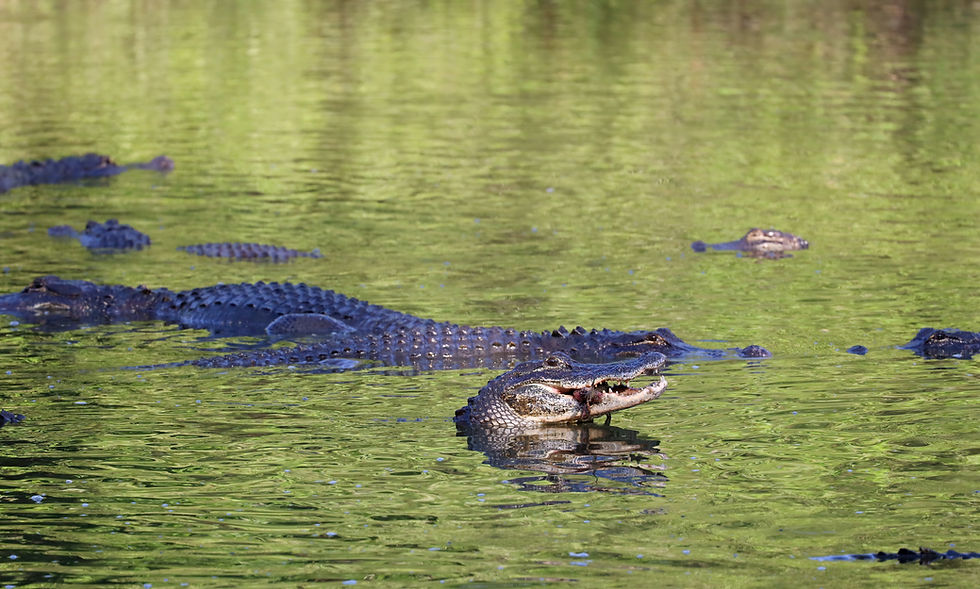
The Okefenokee's defining trait is its water chemistry. Rainfall percolating through centuries of accumulated peat and decaying vegetation picks up tannins and organic acids, producing the tea-black, mildly acidic water that gives the swamp its color and, in large part, its ecological character. That blackwater, low in dissolved oxygen and naturally acidic, still supports one of the densest concentrations of American alligators anywhere in their range, along with black bears using the swamp's forested islands and hammocks, sandhill cranes that winter in the open prairies, and a long list of wading birds and reptiles adapted to a slow, tannin-stained hydrology. The refuge's open-water prairies, cypress stands, and floating peat islands, known locally as 'houses' because they occasionally break loose and drift, create a mosaic that is more wetland prairie than classic forested swamp in large sections, a distinction that shapes both the wildlife and the paddling experience.
The Altamaha, by contrast, is a brownwater river, formed by the confluence of the Ocmulgee and Oconee near Lumber City and running roughly 137 miles to the Atlantic, making it Georgia's largest river by discharge and one of the largest undammed river systems on the East Coast. The Nature Conservancy has referred to it as Georgia's 'Little Amazon' for the biodiversity it carries through a corridor with minimal shoreline development, including rare mussel and fish species found nowhere else. Where the Altamaha reaches tidewater near Darien, it built one of the largest deltas on the Atlantic seaboard, ground that nineteenth-century planters converted into an extensive network of diked rice impoundments. Many of those impoundments, along with similar systems on the Satilla River to the south, are now managed as waterfowl habitat, giving the Georgia coast a wetland type -- structured, water-controlled, historically engineered -- that has no real analog in the Okefenokee's natural peat basin. The third ecological register is the sea-island estuary itself: the spartina marsh, oyster reef, and tidal creek system that wraps Cumberland Island, Sapelo Island, Jekyll Island, and St. Simons Island, among the most productive and least fragmented salt marsh complexes remaining on the Atlantic coast.
What the Interface Creates
The interesting sporting ground in southeast Georgia sits at the seams between these three systems, not in the middle of any one of them. Blackwater swamp ecology, coastal-impoundment waterfowl habitat, and open Atlantic estuary do not simply sit side by side -- they interact along river corridors and migration routes in ways that concentrate wildlife and create distinct, layered opportunity. The Okefenokee functions as a headwater reservoir and refuge, holding resident alligator, bear, and wading-bird populations largely insulated from the coast, while also seeding the Suwannee and St. Marys systems that carry its water and its nutrient signature outward.
Downstream, the Altamaha corridor and its coastal impoundments sit squarely inside the Atlantic Flyway, one of four major North American migratory bird corridors recognized by the U.S. Fish and Wildlife Service's Atlantic Flyway Council, and the historic rice-field engineering on the lower river gives migrating and wintering waterfowl a food-rich, water-managed habitat type that is otherwise scarce on a coast dominated by open marsh. Finally, where the coastline opens into the Atlantic proper, the sea-island estuary system -- and the plantation-era sporting tradition tied to islands like Sea Island, Jekyll, and portions of the Camden County mainland -- created a private hunting and fishing culture with real parallels to the Red Hills quail country of southwest Georgia, though built on marsh and timber rather than longleaf pine uplands. The result is a coast where a paddler can be in genuine wilderness, a waterfowler can be working an engineered rice impoundment with two centuries of history behind it, and an inshore angler can be running a skiff through open Atlantic tide, all within roughly a hundred miles of each other.
Migration and Timing Signals
Timing on this coast is set by three largely independent clocks. The Atlantic Flyway drives waterfowl activity on the Altamaha and Satilla impoundments, with the bulk of duck migration and wintering activity concentrated from roughly late November through January, peaking around the December-January window when northern freezes push birds south into Georgia's ice-free coastal marsh and managed impoundments. Georgia's Department of Natural Resources Wildlife Resources Division sets specific season dates and bag limits annually within federal frameworks, and those dates should always be confirmed for the current year rather than assumed from past seasons.
Inshore saltwater fishing around the Golden Isles runs on a different rhythm entirely. Redfish and spotted seatrout are present in the marsh creeks and estuary flats around St. Simons, Jekyll, and Sapelo essentially year-round, but activity intensifies in spring and fall as water temperatures moderate, with redfish schooling behavior on shallow flats especially pronounced in fall. Tarpon push into the Georgia coast's nearshore and inlet waters in a summer window, roughly June through September, when water temperatures climb into their preferred range, making them a distinctly seasonal target compared to the resident redfish and trout fishery. The Okefenokee runs on a third clock altogether: paddling conditions are generally best in the cooler months, from fall through spring, when water levels tend to be more reliable and insect pressure is lower, while the swamp's interior overnight paddling permits, issued by the U.S. Fish and Wildlife Service refuge office, operate on an advance-reservation system with limited nightly capacity that should be checked directly with the refuge well ahead of any planned trip, since availability and the reservation process have changed over time.
On the Ground
Waycross and Folkston function as the two gateway towns to the Okefenokee, sitting on opposite sides of the refuge. Waycross, home to the privately operated Okefenokee Swamp Park, anchors the north entrance and has long marketed itself as the swamp's gateway city, while Folkston sits closer to the refuge's east entrance and the Suwannee Canal Recreation Area, the most heavily used access point into the interior. On the swamp's west side, Stephen C. Foster State Park in Fargo offers a quieter, more remote entrance with its own cabin and camping infrastructure, popular with paddlers heading into the swamp's less-trafficked prairies.
On the coast, Brunswick serves as the practical hub for the Golden Isles, a working port city with the marina and charter infrastructure to support inshore fishing operations reaching St. Simons, Jekyll, and Sapelo waters. Darien, smaller and quieter, sits directly on the Altamaha's tidewater and functions as the natural basecamp for river guides and waterfowl outfitters working the delta and its historic rice impoundments. St. Simons Island and Sea Island round out the picture as the resort and lodging anchors of the coastal sporting tradition, with Sea Island in particular carrying the tightly held plantation-hunting culture that defines the region's most exclusive sporting access, largely inaccessible outside of member or guest relationships.
Planning Your Trip: A Vertical-by-Vertical Breakdown
Okefenokee Paddling and Permit Hunting. Target: interior blackwater paddling routes through the refuge's prairies and cypress corridors, plus limited permit-based hunting access on refuge lands. Peak: fall through spring for paddling, when water levels and temperatures are most favorable; hunting access follows Georgia DNR and USFWS refuge-specific season and permit calendars set annually. Where: entry points at Suwannee Canal Recreation Area near Folkston, Stephen C. Foster State Park near Fargo, and the Okefenokee Swamp Park near Waycross, each offering a different character of access. Key dependency: overnight interior paddling requires an advance permit reservation through the refuge, with limited nightly capacity; confirm current reservation procedures and any hunting-access rules directly with USFWS before planning a trip.
Altamaha Waterfowl. Target: duck hunting on the Altamaha's lower river corridor and its historic diked rice impoundments, along with similar habitat on the Satilla River. Peak: the core Atlantic Flyway wintering window, roughly late November through January, with activity generally strongest after northern cold fronts push additional birds south. Where: coastal impoundments and WMA lands along the Altamaha near Darien and the lower Satilla in Camden and Glynn Counties. Key dependency: Georgia DNR Wildlife Resources Division sets specific season dates, zones, and bag limits each year within federal Atlantic Flyway frameworks; these should be checked for the current season rather than assumed.
Sea Island Inshore Fishing. Target: redfish and spotted seatrout in the marsh creeks and flats around St. Simons, Jekyll, and Sapelo, with a seasonal tarpon fishery layered on top. Peak: redfish and trout are workable in most months but peak in spring and fall as water temperatures moderate; tarpon run roughly June through September in nearshore and inlet waters. Where: the tidal creek and marsh systems of Glynn County around St. Simons and Jekyll, and the broader estuary bordering Sapelo Island NERR to the north. Key dependency: inshore fishing here is tide-driven more than season-driven for redfish and trout, so trip timing around tide stage matters as much as calendar month; tarpon presence depends on water temperature and can shift year to year.
Key Takeaways
Southeast Georgia is not one ecosystem but three connected ones: the Okefenokee's blackwater peat basin, the Altamaha's brownwater river-and-delta corridor, and the Atlantic sea-island estuary, each with distinct water chemistry, wildlife, and sporting traditions, linked by shared rivers and migration routes rather than by geographic proximity alone.
Timing on this coast has to be read on three separate clocks: Okefenokee paddling and permit access follows refuge-specific reservation rules and seasonal water conditions, Altamaha and Satilla waterfowl follow the Atlantic Flyway's late-fall-through-winter wintering window, and Golden Isles inshore fishing runs largely year-round with a tide-driven rhythm and a distinct summer tarpon season layered on top.
The region's basecamps split cleanly by geography: Waycross and Folkston serve the Okefenokee's north and east entrances, Stephen C. Foster State Park serves the quieter west side, Darien anchors the Altamaha delta and its waterfowl impoundments, and Brunswick, St. Simons, and Sea Island anchor the coastal inshore fishery and the region's historic plantation-hunting tradition.
For the Operators
The operator landscape here is fragmented and, in the Okefenokee's case, genuinely under the radar. Paddle outfitters and permit-hunting assist operations serving the refuge work a small, specialized market that gets a fraction of the visibility of comparable blackwater destinations in Florida or the Low Country, in part because the refuge's own reservation system controls access and limits volume rather than any outfitter marketing effort. Altamaha river guides and coastal-impoundment waterfowl outfitters are similarly scattered across Darien, the lower Satilla, and the broader McIntosh and Glynn County area, without a dominant regional brand or booking platform pulling the category together, which leaves real room for an operator willing to build search and content presence around the Altamaha's ecological story specifically.
The coastal fishing and hunting market splits into two very different competitive environments. St. Simons and Jekyll inshore captains compete in a moderately saturated booking market, one with enough charter volume and enough visibility from the broader Golden Isles tourism economy that differentiation has to come from specialization, whether that is tarpon-season expertise, fly-fishing focus, or deep local knowledge of specific marsh systems. Sea Island's plantation-hunting tradition sits at the opposite end of the spectrum: tightly held, largely relationship-based, and structurally similar to the Red Hills quail plantations of southwest Georgia, where access runs through membership and long-standing guest relationships rather than open booking channels. Any operator or agency working this coast needs to recognize which of these two models a given property or outfitter actually fits, because the marketing approach that works for a St. Simons charter captain will not translate to a Sea Island plantation operation, and treating them as the same category is a fast way to misread the market.
Citations and Sources
This report draws on publicly available information from the following agencies and conservation organizations; operators and travelers should confirm current season dates, permit rules, and access conditions directly with each agency before planning a trip.
Agencies and sources
Primary sources referenced include the Georgia Department of Natural Resources Wildlife Resources Division, the U.S. Fish and Wildlife Service's Okefenokee National Wildlife Refuge, the U.S. Fish and Wildlife Service and National Park Service for Cumberland Island National Seashore, the Sapelo Island National Estuarine Research Reserve administered through NOAA, The Nature Conservancy's Georgia chapter, Audubon Georgia, the U.S. Fish and Wildlife Service's Atlantic Flyway Council, and the Coastal Conservation Association of Georgia.
Confidence note: The Okefenokee's size (roughly 700 square miles for the broader swamp ecosystem, with the federal refuge itself covering a somewhat smaller acreage), the Altamaha's status as Georgia's largest and one of the East Coast's least-developed major rivers, and the origin of the Suwannee and St. Marys Rivers in the Okefenokee are all well-established public facts. Waterfowl season dates, bag limits, and Okefenokee permit-reservation procedures change year to year and were intentionally described here in general seasonal terms rather than specific dates; readers should confirm current rules with Georgia DNR and the refuge directly. Tarpon and inshore fishing timing reflects general regional patterns rather than a specific data source and can shift with water temperature from year to year. The characterization of Sea Island's hunting tradition as tightly held and membership-based reflects the general, well-known character of that coastal sporting culture rather than any specific operator or property, and no operator names, prices, or figures have been included anywhere in this report.
Explore More
For related ecological and regional context, see these other Pine & Marsh field reports and species profiles.


Comments