
Wild Hog Ecology of the Georgia Wiregrass: Telfair and Berrien Counties

Drive the back roads between Lumber City and Alapaha in late summer and the land tells two stories at once. One is written in straight rows: peanuts drying on windrows, center-pivot corn gone gold, young loblolly stands climbing out of the Tifton Upland sand. The other is written in torn ground -- irregular black gouges through a roadside broomsedge patch, a food plot plowed overnight by something with no interest in a planting calendar. This is the Georgia Wiregrass, a working landscape of pine plantation and row-crop agriculture stitched together by the Ocmulgee, Altamaha, and Alapaha River systems, and it sits at the eastern edge of a much older and more specialized landscape tradition: the longleaf pine and wiregrass country that has sustained wild-quail management on private plantations for more than a century. Feral hogs -- Sus scrofa, the same Eurasian-derived species found from Texas to the Carolinas -- have built one of their highest-density populations anywhere in Georgia in this corridor. Where that population overlaps with land still managed for wild bobwhite, the rooting, the egg predation, and the disrupted groundcover put a genuinely invasive species in direct conflict with one of the Southeast's oldest conservation economies.
Quail Country and the Cost of a Rooted Understory
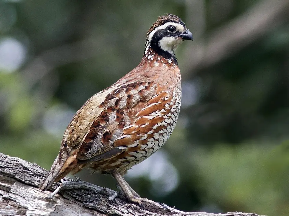
The Northern bobwhite quail (Colinus virginianus) does not need much from the ground layer, but it needs it to be intact. A nesting hen wants a shallow scrape hidden in a clump of wiregrass or broomsedge, open enough at ground level for a chick to move through on foot but closed enough overhead to hide the nest from a hawk's eye or a predator's nose. That structure -- native bunchgrass, scattered forbs, bare soil microsites for dusting and brood movement -- is the product of decades of prescribed fire and habitat investment on the plantations and managed private tracts along the corridor's western margin, in counties like Thomas, Brooks, Grady, and Mitchell where wild-quail management is most intensive. It is also, unfortunately, exactly the kind of structure a rooting sounder destroys in a single pass.
A hog's snout is built for exactly this work. The prenasal bone and cartilaginous rostral disk let an animal overturn several kilograms of sandy Tifton Upland soil in one push, and the same olfactory sensitivity that lets swine locate peanuts fifteen to twenty centimeters underground also lets them detect the thermal and chemical signature of a ground nest full of eggs. Quail nesting runs from March through July, and swine forage year-round through that same window. Where wiregrass groundcover is fragmented by rooting, the fine, continuous fuel bed that carries frequent low-intensity fire is broken up as well -- fire behavior turns patchy, burn intervals stretch, and the hardwood mid-story that fire is supposed to hold back (gallberry, saw palmetto, sparkleberry, rusty lyonia) starts climbing. Research bodies including the Southeast Quail Study Group and Tall Timbers Research Station have identified feral swine as a documented threat to bobwhite productivity across the longleaf-wiregrass ecosystem, both through direct nest predation and through this slower degradation of nesting structure.
The damage extends past the nest. Supplemental feed -- corn or milo distributed in food plots and feed stations to carry quail coveys through the lean months -- is itself a magnet for rooting. A hog that finds a food plot will work it methodically, and the same high-caloric-density behavior that makes swine efficient at excavating peanut pods makes them efficient at cleaning out a feeder site, reducing its value to the birds it was built for and, in some cases, damaging the plot's cover value along with its feed value.
What makes this conflict notable is the asymmetry in response. On the plantation belt's western margin, quail management is the primary land-use objective, and swine suppression is treated as a direct extension of that management -- landowners run structured removal programs because a hog population left unchecked will erode the habitat investment they are making every season. Move east into the corridor's commercial pine timber zone, where quail management is absent or far less intensive, and swine are more often tolerated as a secondary hunting product than actively suppressed. The ecological cost of that difference in intensity falls on the quail population itself, which in the eastern zone lacks the same management advocacy the plantation belt provides.
Quail are not the only ground-nesting species absorbing that cost. Wild turkey hens in the corridor have been shown, in research published in PLOS ONE by Tanner and colleagues in 2021, to alter their reproductive-season movements and nesting habitat selection in direct response to the presence of wild pigs -- a finding that points to the same pressure operating on a second game bird managed intensively across the corridor's private and public land. The gopher tortoise, a longleaf sandhill specialist whose shallow nests of four to eight eggs sit ten to twenty-five centimeters below the surface, is vulnerable to the same detection-and-excavation behavior, and because a single gopher tortoise burrow system provides thermal refuge for roughly 360 commensal species -- including the federally threatened eastern indigo snake -- nest predation by swine has consequences that extend well past the tortoise itself into the broader sandhill community it supports.
A Landscape Built to Feed a Population
The Wiregrass corridor's core counties -- Telfair, Berrien, Irwin, Coffee, Atkinson, Ware, Brantley, Pierce, and Jeff Davis, with an extended zone reaching into Ben Hill, Wilcox, Clinch, Echols, Lanier, and Bacon -- sit atop Tifton Upland sandy loam, a soil type that is dramatically easier to root than the heavier clay of the Piedmont or the Alabama Black Belt. That geology, combined with a subtropical climate that rarely produces a hard freeze and a growing season exceeding 270 days in most years, has made this corridor the documented highest-density feral swine concentration in Georgia, part of a statewide population that GADNR estimates at 500,000 to 600,000 animals present in all 159 counties.
Agriculture is the other half of the equation. The wiregrass zone is one of the most productive peanut-producing regions in the United States, and peanuts are the single row crop most vulnerable to swine damage in the Southeast, since the pods develop underground directly in the sandy root zone swine root most efficiently. A sounder of ten to fifteen animals can destroy five to ten acres of peanuts in a single night during the August-through-October harvest window, when mature pods sit near the surface during windrow and combine operations. Corn sustains damage on both ends of its growing cycle -- rooted-up seed and seedlings at germination, consumed ears at the dough and dent stages -- and cotton adds to the cumulative loss. Nationally, USDA APHIS estimates feral swine agricultural damage at approximately $2.5 billion annually, and the concentration of peanut, corn, and cotton production in the core Wiregrass counties represents one of the higher per-county damage totals in the eastern United States.
Timber is not exempt. Commercial pine plantation -- loblolly and slash pine grown for pulp and sawtimber -- is the dominant upland land use across counties like Coffee, Berrien, Atkinson, Jeff Davis, and Irwin, and the eighteen-to-thirty-six-month window after a clear-cut is replanted is the period of greatest vulnerability, when swine root through fresh seedling beds. Site preparation and replanting for loblolly pine at standard eight-by-eight-foot spacing runs roughly $150 to $300 per acre, a reasonable proxy for what rooting damage severe enough to require replanting actually costs a timber operation, and it is this recurring cost that has pushed some timber companies toward cooperative hunting-lease arrangements that put removal effort on their land.
The Wiregrass zone also sits in a broader agricultural belt known for Vidalia sweet onions and blueberry production, both regionally significant crops in south Georgia. The available source research for this corridor does not document swine damage specifically to onions or blueberries with the same depth it documents for peanuts, corn, and cotton, and this piece does not extend claims about those crops beyond that general regional context.
Rivers as Corridors: Movement Between the Ocmulgee and the Alapaha
Feral swine do not distribute themselves evenly across a landscape like the Wiregrass -- they concentrate in river swamp bottomland, and the river systems that drain the corridor function as both population reservoirs and movement highways. The Altamaha River, formed at the confluence of the Ocmulgee and Oconee near Lumber City in Telfair County, combines year-round water, dense overhanging cover, and abundant soft and hard mast in a way that sustains the highest swine densities in the corridor across all seasons. The Nature Conservancy has designated the Altamaha one of the 75 last great places on Earth, prized for its extraordinary freshwater mussel diversity -- a diversity that swine-driven bank erosion, floodplain rooting, and sedimentation put under additional pressure alongside the river's other water-quality stressors.
To the south and east, the Alapaha River drains through Irwin, Berrien, and Lanier Counties before crossing into Florida and joining the Suwannee system. That connection is more than geographic. The Suwannee watershed in north-central Florida supports one of the two largest state-level feral swine populations in the country, estimated at 500,000 to 1,000,000 animals, and the Alapaha-Suwannee corridor functions as a continuous, unbroken travel route between the two populations. It is also a documented disease-transmission pathway. Practically, this means population suppression efforts focused on Berrien, Lanier, and Echols Counties can be partially offset by animals moving north out of the Suwannee basin -- a dynamic that no Georgia-only management program can fully control on its own.
The Georgia Withlacoochee River, also flowing out of Irwin County toward the Suwannee, and the Satilla River's headwaters in Ware and Atkinson Counties round out the corridor's drainage network, each providing the same combination of year-round water and dense cover that makes river swamp the population core from which swine rebuild numbers between removal events. The Okefenokee National Wildlife Refuge, whose northern margin lies in Ware County adjacent to the corridor's eastern edge, adds another layer: its deep interior functions as a low-pressure refuge that can reinforce swine numbers on the adjacent, more heavily hunted Dixon Memorial Wildlife Management Area, a 37,000-plus-acre public tract managed by GADNR.
The Longleaf Cascade Behind the Quail Problem
The quail habitat damage described above does not happen in isolation -- it is one expression of a larger ecological cascade tied to the longleaf pine ecosystem that once defined this part of Georgia. The longleaf pine's historic range in the state exceeded four million acres; by the late twentieth century, fewer than 376,400 acres remained, a reduction of more than 90 percent, and the sandy-loam uplands of the Wiregrass corridor represent some of the state's highest-potential land for restoring it. Feral swine are among the most significant obstacles to that restoration. A longleaf seedling spends seven to fifteen years in a grass stage before it bolts upward, storing its energy reserve in a belowground terminal bud that also happens to be a high-starch food item swine seek out by rooting. A single sounder working a restoration planting overnight can destroy hundreds of grass-stage seedlings across several acres, eliminating years of growth investment in one pass.
The secondary effect is the one that ties most directly back to quail. Wiregrass groundcover is the fine fuel that carries the frequent, low-intensity, growing-season fire longleaf ecosystems depend on. When rooting fragments that groundcover, fire-return intervals lengthen and hardwood mid-story species accelerate into the gap, eventually shading out the very wiregrass structure that both longleaf regeneration and quail nesting depend on. It is a feedback loop -- rooting fragments wiregrass, wiregrass loss lengthens fire intervals, longer fire intervals allow hardwood encroachment, hardwood encroachment suppresses both longleaf seedlings and quail nesting cover -- and it is one of the more consequential cascades associated with feral swine anywhere in the coastal plain.
Sounders, Seasons, and the Arithmetic of Growth
Part of what makes the Wiregrass corridor so difficult to manage is simple biology. Sows here reach sexual maturity at six to ten months under the corridor's exceptional nutritional conditions, carry a gestation of 114 to 115 days, and average litters of four to six piglets -- with sows in optimal condition, which the corridor's peanut and mast resources readily support, capable of producing two litters in a single year. Sounders typically run four to twelve animals built around a dominant sow and her kin, moving across home ranges of four to twenty square kilometers, with boars ranging more widely and largely solitary outside the breeding season. Because the region's subtropical climate removes the winter energy constraint that suppresses reproduction in northern swine populations, breeding continues essentially year-round.
That reproductive profile produces a population growth rate recreational hunting was never built to overcome on its own. USDA National Wildlife Research Center modeling and field studies consistently find that 60 to 70 percent or more of a local population has to be removed annually just to hold numbers flat, a bar that intensive, coordinated removal can approach in accessible habitat during peak season but that scattered recreational hunting pressure rarely clears across an entire year, particularly in the river-swamp interior where dense cover limits both visibility and access. Seasonally, the corridor's swine track the food supply closely: concentrating on peanut and corn field margins by night from August through October, shifting into bottomland oak mast and the sandhill-longleaf transition zone from October through December as breeding condition peaks, falling back to food plots, field waste, and forest foraging in the wetter months of January through April, and producing the spring's new piglets from April through June as green browse and agricultural disturbance create a second seasonal foraging pulse.
That same seasonal and reproductive dynamic explains why the corridor's population never fully collapses in response to any single removal method. A trapping program that clears a bottomland sounder in November faces a landscape where a neighboring sow may already be carrying a litter conceived during the fall mast peak, due to arrive well before the same site can be re-baited and re-trapped the following season.
Management Across a Fragmented Ownership Pattern
Georgia treats feral swine as a designated invasive species, and the regulatory framework reflects it. On private land, hogs may be taken year-round with no bag limit, night hunting is permitted, and trapping is authorized under GADNR's permit framework -- rules built around the recognition that swine in high-pressure areas are primarily nocturnal, and that restricting harvest to daylight hours would sharply limit removal effectiveness. Public land carries more restrictive, unit-specific rules; hunters using WMA units like Dixon Memorial, Bullard Creek, Altamaha, or Big Hammock should verify current season dates and method requirements with GADNR before a hunt.
The most population-impactful tool in the corridor is whole-sounder corral trapping, in which a site is pre-baited for seven to fourteen days to condition an entire sounder to a fixed feeding point before a triggered gate captures the group at once. Systems like the BoarBuster suspended drop gate, developed and supported regionally through operations like Jager Pro (headquartered in Columbus, Georgia), have measurably improved whole-sounder capture rates over conventional swing-gate corral traps. USDA APHIS Wildlife Services runs cooperative aerial gunning operations in the corridor's open pine flatwoods and clear-cuts under the National Feral Swine Damage Management Program established in 2014, though effectiveness drops sharply in dense river-swamp cover where canopy closure blocks line-of-sight shooting. Georgia was also included in the USDA NRCS/APHIS Feral Swine Eradication and Control Pilot Program, funded at $75 million under the 2018 Farm Bill across twelve states, with the Georgia project organized around watershed-based removal paired with water-quality monitoring.
The plantation belt's suppression programs remain the corridor's most intensive private response, combining dogs, trapping, and shooting specifically to hold swine density to levels compatible with quail productivity -- a higher-cost, higher-effort model that large private holdings with dedicated management resources can sustain but that is not replicated at the same intensity across the commercial timber zone to the east. That fragmentation of ownership and management intent is, in the end, the corridor's central management challenge: a single connected swine population moving freely across county lines and ownership boundaries where the intensity of the response varies enormously from one tract to the next.
USDA NWRC modeling and field studies indicate that 60 to 70 percent or more of a local population must be removed annually just to hold numbers stable, a threshold recreational hunting alone rarely reaches on a landscape scale, particularly in river-swamp refugia where difficult access limits hunter effectiveness. That reality is why cooperative removal -- trapping partnerships between neighboring landowners, timber companies, and GADNR technical assistance -- has become the more durable management model in the corridor, even where eradication itself is not considered a realistic goal on this open, connected mainland system.
Key Takeaways
The Georgia Wiregrass corridor, centered on Telfair and Berrien Counties, is the documented highest-density feral swine concentration in Georgia, sustained by easily-rooted Tifton Upland sandy loam, a nearly year-round breeding climate, and a habitat mosaic of pine plantation, row-crop agriculture, and river swamp refugia.
Where the corridor overlaps with wild-quail management on its western margin, rooting that fragments wiregrass nesting cover, direct predation of ground nests, and damage to supplemental feed sites put feral swine in direct conflict with a private-lands conservation model built on decades of prescribed fire and habitat investment -- a conflict identified by the Southeast Quail Study Group and Tall Timbers Research Station.
The Alapaha River's connection to Florida's Suwannee watershed, home to one of the two largest state-level feral swine populations in the country, means Georgia-only removal effort in the corridor's southern counties can be partially offset by immigration from Florida -- underscoring why regional, cooperative management across ownership boundaries matters more than any single program.
Citations and Sources
This article draws on Georgia Department of Natural Resources data, USDA APHIS program documentation, and peer-reviewed wildlife research; readers planning removal activity or citing current regulations should confirm status directly with GADNR and APHIS.
Agencies and research
Primary agency sources include the Georgia Department of Natural Resources Wildlife Resources Division, USDA Animal and Plant Health Inspection Service (APHIS) Wildlife Services and its National Feral Swine Damage Management Program, USDA Natural Resources Conservation Service, and the USDA NRCS/APHIS Feral Swine Eradication and Control Pilot Program under the 2018 Farm Bill. The Nature Conservancy's Altamaha River program and America's Longleaf Restoration Initiative provided context on riparian and longleaf ecosystem status.
Peer-reviewed literature
Research referenced includes Tanner et al. (2021, PLOS ONE) on wild pig effects on wild turkey nesting movements, Lipscomb (1989) on feral hog impacts to longleaf pine regeneration, Hanson et al. (2009) on feral swine damage in forested ecosystems, and habitat and population guidance from the Southeast Quail Study Group and Tall Timbers Research Station on Northern bobwhite management in the longleaf-wiregrass ecosystem.
Confidence note: county boundaries, river systems, GADNR regulatory framework, USDA APHIS program details, longleaf pine acreage figures, and reproductive/population figures for feral swine are drawn directly from the source research file and are considered reliable as general, non-time-sensitive ecological facts, though hunters should confirm current-season GADNR and WMA-specific rules before a hunt. Swine impacts on quail nesting and wiregrass structure are supported by Southeast Quail Study Group and Tall Timbers Research Station findings, but corridor-specific quantitative data (for example, precise nest-predation rates in Telfair or Berrien Counties specifically) is not available in the source material and is not claimed here. The Vidalia onion and blueberry references are included only as general regional agricultural context, not as documented swine-damage claims, since the source file does not cover hog impacts to those specific crops. The 800-pound 'Hogzilla' animal taken near Alapaha in Berrien County in 2004 and forensically verified by National Geographic in 2005 is accurately reported per that investigation but represents an exceptional individual, not a typical body size for the population.
Explore More
For readers who want the broader ecological picture behind this corridor, these related pieces cover the regional invasion dynamics and the quail habitat this article touches on.


Comments